|
|
| Zeile 12: |
Zeile 12: |
| | <imagemap> | | | <imagemap> |
| Datei:Rhein-Maas-Schelde.png|1000px | | Datei:Rhein-Maas-Schelde.png|1000px |
| circle 490 173 7 [[#info1|Harmsenbrug]] | | circle 554 761 7 [[#info1|Rupelbrug/Boulevardbrug]] |
| circle 486 179 7 [[#info1|Harmsenbrug]] | | circle 558 755 7 [[#info1|Rupelbrug/Boulevardbrug]] |
| circle 485 180 7 [[#info1|Harmsenbrug]] | | circle 563 750 7 [[#info1|Rupelbrug/Boulevardbrug]] |
| circle 483 183 7 [[#info2|Brielsebrug]] | | circle 565 748 7 [[#info1|Rupelbrug/Boulevardbrug]] |
| circle 479 188 7 [[#info2|Brielsebrug]] | | circle 490 173 7 [[#info2|Harmsenbrug]] |
| circle 477 192 7 [[#info2|Brielsebrug]] | | circle 486 179 7 [[#info2|Harmsenbrug]] |
| circle 539 191 7 [[#info3|Botlekbrug]] | | circle 485 180 7 [[#info2|Harmsenbrug]] |
| circle 546 190 7 [[#info3|Botlekbrug]] | | circle 483 183 7 [[#info3|Brielsebrug]] |
| circle 553 190 7 [[#info3|Botlekbrug]] | | circle 479 188 7 [[#info3|Brielsebrug]] |
| circle 553 190 7 [[#info3|Botlekbrug]] | | circle 477 192 7 [[#info3|Brielsebrug]] |
| circle 529 190 7 [[#info4|Hartelbrug]] | | circle 539 191 7 [[#info4|Botlekbrug]] |
| circle 529 197 7 [[#info4|Hartelbrug]] | | circle 546 190 7 [[#info4|Botlekbrug]] |
| circle 529 204 7 [[#info4|Hartelbrug]] | | circle 553 190 7 [[#info4|Botlekbrug]] |
| circle 529 211 7 [[#info4|Hartelbrug]] | | circle 553 190 7 [[#info4|Botlekbrug]] |
| circle 530 214 7 [[#info4|Hartelbrug]] | | circle 529 190 7 [[#info5|Hartelbrug]] |
| circle 708 100 7 [[#info5|Gouderaksebrug]] | | circle 529 197 7 [[#info5|Hartelbrug]] |
| circle 708 106 7 [[#info5|Gouderaksebrug]] | | circle 529 204 7 [[#info5|Hartelbrug]] |
| circle 709 113 7 [[#info5|Gouderaksebrug]] | | circle 529 211 7 [[#info5|Hartelbrug]] |
| circle 709 116 7 [[#info5|Gouderaksebrug]] | | circle 530 214 7 [[#info5|Hartelbrug]] |
| circle 444 159 7 [[#info6|Brielse Maasdam]] | | circle 708 100 7 [[#info6|Gouderaksebrug]] |
| circle 443 166 7 [[#info6|Brielse Maasdam]] | | circle 708 106 7 [[#info6|Gouderaksebrug]] |
| circle 443 169 7 [[#info6|Brielse Maasdam]] | | circle 709 113 7 [[#info6|Gouderaksebrug]] |
| circle 449 147 7 [[#info7|Suurhoffbrug]] | | circle 709 116 7 [[#info6|Gouderaksebrug]] |
| circle 446 153 7 [[#info7|Suurhoffbrug]] | | circle 444 159 7 [[#info7|Brielse Maasdam]] |
| circle 444 156 7 [[#info7|Suurhoffbrug]] | | circle 443 166 7 [[#info7|Brielse Maasdam]] |
| circle 415 156 7 [[#info8|Brielse Gatdam]] | | circle 443 169 7 [[#info7|Brielse Maasdam]] |
| circle 420 160 7 [[#info8|Brielse Gatdam]] | | circle 449 147 7 [[#info8|Suurhoffbrug]] |
| circle 425 165 7 [[#info8|Brielse Gatdam]] | | circle 446 153 7 [[#info8|Suurhoffbrug]] |
| circle 430 170 7 [[#info8|Brielse Gatdam]] | | circle 444 156 7 [[#info8|Suurhoffbrug]] |
| circle 431 171 7 [[#info8|Brielse Gatdam]] | | circle 415 156 7 [[#info9|Brielse Gatdam]] |
| circle 681 234 7 [[#info9|Stadsbrug Zwijndrecht]] | | circle 420 160 7 [[#info9|Brielse Gatdam]] |
| circle 687 238 7 [[#info9|Stadsbrug Zwijndrecht]] | | circle 425 165 7 [[#info9|Brielse Gatdam]] |
| circle 692 242 7 [[#info9|Stadsbrug Zwijndrecht]] | | circle 430 170 7 [[#info9|Brielse Gatdam]] |
| circle 695 245 7 [[#info9|Stadsbrug Zwijndrecht]] | | circle 431 171 7 [[#info9|Brielse Gatdam]] |
| circle 683 209 7 [[#info10|Brug over de Noord]] | | circle 681 234 7 [[#info10|Stadsbrug Zwijndrecht]] |
| circle 689 208 7 [[#info10|Brug over de Noord]] | | circle 687 238 7 [[#info10|Stadsbrug Zwijndrecht]] |
| circle 696 207 7 [[#info10|Brug over de Noord]] | | circle 692 242 7 [[#info10|Stadsbrug Zwijndrecht]] |
| circle 699 207 7 [[#info10|Brug over de Noord]] | | circle 695 245 7 [[#info10|Stadsbrug Zwijndrecht]] |
| circle 730 224 7 [[#info11|Baanhoekbrug]] | | circle 683 209 7 [[#info11|Brug over de Noord]] |
| circle 729 230 7 [[#info11|Baanhoekbrug]] | | circle 689 208 7 [[#info11|Brug over de Noord]] |
| circle 729 237 7 [[#info11|Baanhoekbrug]] | | circle 696 207 7 [[#info11|Brug over de Noord]] |
| circle 729 240 7 [[#info11|Baanhoekbrug]] | | circle 699 207 7 [[#info11|Brug over de Noord]] |
| circle 712 219 7 [[#info12|Merwedebrug]] | | circle 730 224 7 [[#info12|Baanhoekbrug]] |
| circle 713 226 7 [[#info12|Merwedebrug]] | | circle 729 230 7 [[#info12|Baanhoekbrug]] |
| circle 713 233 7 [[#info12|Merwedebrug]] | | circle 729 237 7 [[#info12|Baanhoekbrug]] |
| circle 714 239 7 [[#info12|Merwedebrug]] | | circle 729 240 7 [[#info12|Baanhoekbrug]] |
| circle 957 224 7 [[#info13|Martinus Nijhoffbrug]] | | circle 712 219 7 [[#info13|Merwedebrug]] |
| circle 958 230 7 [[#info13|Martinus Nijhoffbrug]] | | circle 713 226 7 [[#info13|Merwedebrug]] |
| circle 959 237 7 [[#info13|Martinus Nijhoffbrug]] | | circle 713 233 7 [[#info13|Merwedebrug]] |
| circle 961 244 7 [[#info13|Martinus Nijhoffbrug]] | | circle 714 239 7 [[#info13|Merwedebrug]] |
| circle 961 246 7 [[#info13|Martinus Nijhoffbrug]] | | circle 957 224 7 [[#info14|Martinus Nijhoffbrug]] |
| circle 872 247 7 [[#info14|Wilhelminasluis]] | | circle 958 230 7 [[#info14|Martinus Nijhoffbrug]] |
| circle 866 251 7 [[#info14|Wilhelminasluis]] | | circle 959 237 7 [[#info14|Martinus Nijhoffbrug]] |
| circle 861 255 7 [[#info14|Wilhelminasluis]] | | circle 961 244 7 [[#info14|Martinus Nijhoffbrug]] |
| circle 962 281 7 [[#info15|Hedelse Brug]] | | circle 961 246 7 [[#info14|Martinus Nijhoffbrug]] |
| circle 963 288 7 [[#info15|Hedelse Brug]] | | circle 872 247 7 [[#info15|Wilhelminasluis]] |
| circle 964 295 7 [[#info15|Hedelse Brug]] | | circle 866 251 7 [[#info15|Wilhelminasluis]] |
| circle 964 298 7 [[#info15|Hedelse Brug]] | | circle 861 255 7 [[#info15|Wilhelminasluis]] |
| circle 895 284 7 [[#info16|Kromme Nol]] | | circle 962 281 7 [[#info16|Hedelse Brug]] |
| circle 902 284 7 [[#info16|Kromme Nol]] | | circle 963 288 7 [[#info16|Hedelse Brug]] |
| circle 908 284 7 [[#info16|Kromme Nol]] | | circle 964 295 7 [[#info16|Hedelse Brug]] |
| circle 636 162 7 [[#info17|Van Brienenoordbrug]] | | circle 964 298 7 [[#info16|Hedelse Brug]] |
| circle 638 168 7 [[#info17|Van Brienenoordbrug]] | | circle 895 284 7 [[#info17|Kromme Nol]] |
| circle 641 175 7 [[#info17|Van Brienenoordbrug]] | | circle 902 284 7 [[#info17|Kromme Nol]] |
| circle 643 180 7 [[#info17|Van Brienenoordbrug]] | | circle 908 284 7 [[#info17|Kromme Nol]] |
| circle 610 160 7 [[#info18|Erasmusbrug/Willemsbrug]] | | circle 636 162 7 [[#info18|Van Brienenoordbrug]] |
| circle 614 166 7 [[#info18|Erasmusbrug/Willemsbrug]] | | circle 638 168 7 [[#info18|Van Brienenoordbrug]] |
| circle 618 171 7 [[#info18|Erasmusbrug/Willemsbrug]] | | circle 641 175 7 [[#info18|Van Brienenoordbrug]] |
| circle 621 176 7 [[#info18|Erasmusbrug/Willemsbrug]] | | circle 643 180 7 [[#info18|Van Brienenoordbrug]] |
| circle 816 239 7 [[#info19|Merwedebrug]] | | circle 610 160 7 [[#info19|Erasmusbrug/Willemsbrug]] |
| circle 817 232 7 [[#info19|Merwedebrug]] | | circle 614 166 7 [[#info19|Erasmusbrug/Willemsbrug]] |
| circle 819 225 7 [[#info19|Merwedebrug]] | | circle 618 171 7 [[#info19|Erasmusbrug/Willemsbrug]] |
| circle 820 218 7 [[#info19|Merwedebrug]] | | circle 621 176 7 [[#info19|Erasmusbrug/Willemsbrug]] |
| circle 821 217 7 [[#info19|Merwedebrug]] | | circle 816 239 7 [[#info20|Merwedebrug]] |
| circle 794 311 7 [[#info20|Keizerveersbrug]] | | circle 817 232 7 [[#info20|Merwedebrug]] |
| circle 795 304 7 [[#info20|Keizerveersbrug]] | | circle 819 225 7 [[#info20|Merwedebrug]] |
| circle 796 297 7 [[#info20|Keizerveersbrug]] | | circle 820 218 7 [[#info20|Merwedebrug]] |
| circle 797 296 7 [[#info20|Keizerveersbrug]] | | circle 821 217 7 [[#info20|Merwedebrug]] |
| circle 890 289 7 [[#info21|Heusdensebrug]] | | circle 794 311 7 [[#info21|Keizerveersbrug]] |
| circle 893 295 7 [[#info21|Heusdensebrug]] | | circle 795 304 7 [[#info21|Keizerveersbrug]] |
| circle 896 301 7 [[#info21|Heusdensebrug]] | | circle 796 297 7 [[#info21|Keizerveersbrug]] |
| circle 662 166 7 [[#info22|Algerabrug]] | | circle 797 296 7 [[#info21|Keizerveersbrug]] |
| circle 655 164 7 [[#info22|Algerabrug]] | | circle 890 289 7 [[#info22|Heusdensebrug]] |
| circle 650 162 7 [[#info22|Algerabrug]] | | circle 893 295 7 [[#info22|Heusdensebrug]] |
| circle 686 278 7 [[#info23|Kiltunnel]] | | circle 896 301 7 [[#info22|Heusdensebrug]] |
| circle 679 277 7 [[#info23|Kiltunnel]] | | circle 662 166 7 [[#info23|Algerabrug]] |
| circle 672 277 7 [[#info23|Kiltunnel]] | | circle 655 164 7 [[#info23|Algerabrug]] |
| circle 669 277 7 [[#info23|Kiltunnel]] | | circle 650 162 7 [[#info23|Algerabrug]] |
| circle 693 322 7 [[#info24|Moerdijkbrug]] | | circle 686 278 7 [[#info24|Kiltunnel]] |
| circle 690 315 7 [[#info24|Moerdijkbrug]] | | circle 679 277 7 [[#info24|Kiltunnel]] |
| circle 688 309 7 [[#info24|Moerdijkbrug]] | | circle 672 277 7 [[#info24|Kiltunnel]] |
| circle 686 302 7 [[#info24|Moerdijkbrug]] | | circle 669 277 7 [[#info24|Kiltunnel]] |
| circle 684 296 7 [[#info24|Moerdijkbrug]] | | circle 693 322 7 [[#info25|Moerdijkbrug]] |
| circle 434 346 7 [[#info25|Grevelingendam/Philipsdam]] | | circle 690 315 7 [[#info25|Moerdijkbrug]] |
| circle 440 343 7 [[#info25|Grevelingendam/Philipsdam]] | | circle 688 309 7 [[#info25|Moerdijkbrug]] |
| circle 447 340 7 [[#info25|Grevelingendam/Philipsdam]] | | circle 686 302 7 [[#info25|Moerdijkbrug]] |
| circle 453 338 7 [[#info25|Grevelingendam/Philipsdam]] | | circle 684 296 7 [[#info25|Moerdijkbrug]] |
| circle 460 335 7 [[#info25|Grevelingendam/Philipsdam]] | | circle 434 346 7 [[#info26|Grevelingendam/Philipsdam]] |
| circle 466 333 7 [[#info25|Grevelingendam/Philipsdam]] | | circle 440 343 7 [[#info26|Grevelingendam/Philipsdam]] |
| circle 467 333 7 [[#info25|Grevelingendam/Philipsdam]] | | circle 447 340 7 [[#info26|Grevelingendam/Philipsdam]] |
| circle 471 327 7 [[#info25|Grevelingendam/Philipsdam]] | | circle 453 338 7 [[#info26|Grevelingendam/Philipsdam]] |
| circle 475 321 7 [[#info25|Grevelingendam/Philipsdam]] | | circle 460 335 7 [[#info26|Grevelingendam/Philipsdam]] |
| circle 478 318 7 [[#info25|Grevelingendam/Philipsdam]] | | circle 466 333 7 [[#info26|Grevelingendam/Philipsdam]] |
| circle 473 324 7 [[#info25|Grevelingendam/Philipsdam]] | | circle 467 333 7 [[#info26|Grevelingendam/Philipsdam]] |
| circle 469 329 7 [[#info25|Grevelingendam/Philipsdam]] | | circle 471 327 7 [[#info26|Grevelingendam/Philipsdam]] |
| circle 467 333 7 [[#info25|Grevelingendam/Philipsdam]] | | circle 475 321 7 [[#info26|Grevelingendam/Philipsdam]] |
| circle 470 339 7 [[#info25|Grevelingendam/Philipsdam]] | | circle 478 318 7 [[#info26|Grevelingendam/Philipsdam]] |
| circle 473 345 7 [[#info25|Grevelingendam/Philipsdam]] | | circle 473 324 7 [[#info26|Grevelingendam/Philipsdam]] |
| circle 476 351 7 [[#info25|Grevelingendam/Philipsdam]] | | circle 469 329 7 [[#info26|Grevelingendam/Philipsdam]] |
| circle 480 357 7 [[#info25|Grevelingendam/Philipsdam]] | | circle 467 333 7 [[#info26|Grevelingendam/Philipsdam]] |
| circle 483 363 7 [[#info25|Grevelingendam/Philipsdam]] | | circle 470 339 7 [[#info26|Grevelingendam/Philipsdam]] |
| circle 484 366 7 [[#info25|Grevelingendam/Philipsdam]] | | circle 473 345 7 [[#info26|Grevelingendam/Philipsdam]] |
| circle 537 321 7 [[#info26|Hellegatsplein]] | | circle 476 351 7 [[#info26|Grevelingendam/Philipsdam]] |
| circle 543 320 7 [[#info26|Hellegatsplein]] | | circle 480 357 7 [[#info26|Grevelingendam/Philipsdam]] |
| circle 550 320 7 [[#info26|Hellegatsplein]] | | circle 483 363 7 [[#info26|Grevelingendam/Philipsdam]] |
| circle 557 319 7 [[#info26|Hellegatsplein]] | | circle 484 366 7 [[#info26|Grevelingendam/Philipsdam]] |
| circle 564 318 7 [[#info26|Hellegatsplein]] | | circle 537 321 7 [[#info27|Hellegatsplein]] |
| circle 571 318 7 [[#info26|Hellegatsplein]] | | circle 543 320 7 [[#info27|Hellegatsplein]] |
| circle 573 318 7 [[#info26|Hellegatsplein]] | | circle 550 320 7 [[#info27|Hellegatsplein]] |
| circle 577 323 7 [[#info26|Hellegatsplein]] | | circle 557 319 7 [[#info27|Hellegatsplein]] |
| circle 582 328 7 [[#info26|Hellegatsplein]] | | circle 564 318 7 [[#info27|Hellegatsplein]] |
| circle 586 334 7 [[#info26|Hellegatsplein]] | | circle 571 318 7 [[#info27|Hellegatsplein]] |
| circle 591 339 7 [[#info26|Hellegatsplein]] | | circle 573 318 7 [[#info27|Hellegatsplein]] |
| circle 594 343 7 [[#info26|Hellegatsplein]] | | circle 577 323 7 [[#info27|Hellegatsplein]] |
| circle 589 338 7 [[#info26|Hellegatsplein]] | | circle 582 328 7 [[#info27|Hellegatsplein]] |
| circle 585 332 7 [[#info26|Hellegatsplein]] | | circle 586 334 7 [[#info27|Hellegatsplein]] |
| circle 580 327 7 [[#info26|Hellegatsplein]] | | circle 591 339 7 [[#info27|Hellegatsplein]] |
| circle 576 321 7 [[#info26|Hellegatsplein]] | | circle 594 343 7 [[#info27|Hellegatsplein]] |
| circle 573 318 7 [[#info26|Hellegatsplein]] | | circle 589 338 7 [[#info27|Hellegatsplein]] |
| circle 576 311 7 [[#info26|Hellegatsplein]] | | circle 585 332 7 [[#info27|Hellegatsplein]] |
| circle 578 305 7 [[#info26|Hellegatsplein]] | | circle 580 327 7 [[#info27|Hellegatsplein]] |
| circle 581 298 7 [[#info26|Hellegatsplein]] | | circle 576 321 7 [[#info27|Hellegatsplein]] |
| circle 583 292 7 [[#info26|Hellegatsplein]] | | circle 573 318 7 [[#info27|Hellegatsplein]] |
| circle 585 288 7 [[#info26|Hellegatsplein]] | | circle 576 311 7 [[#info27|Hellegatsplein]] |
| circle 486 521 7 [[#info27|Festland - Zuid-Beveland]] | | circle 578 305 7 [[#info27|Hellegatsplein]] |
| circle 492 521 7 [[#info27|Festland - Zuid-Beveland]] | | circle 581 298 7 [[#info27|Hellegatsplein]] |
| circle 499 521 7 [[#info27|Festland - Zuid-Beveland]] | | circle 583 292 7 [[#info27|Hellegatsplein]] |
| circle 506 521 7 [[#info27|Festland - Zuid-Beveland]] | | circle 585 288 7 [[#info27|Hellegatsplein]] |
| circle 513 521 7 [[#info27|Festland - Zuid-Beveland]] | | circle 486 521 7 [[#info28|Festland - Zuid-Beveland]] |
| circle 519 521 7 [[#info27|Festland - Zuid-Beveland]] | | circle 492 521 7 [[#info28|Festland - Zuid-Beveland]] |
| circle 481 378 7 [[#info28|Sint-Philipslandse Brug]] | | circle 499 521 7 [[#info28|Festland - Zuid-Beveland]] |
| circle 487 380 7 [[#info28|Sint-Philipslandse Brug]] | | circle 506 521 7 [[#info28|Festland - Zuid-Beveland]] |
| circle 494 382 7 [[#info28|Sint-Philipslandse Brug]] | | circle 513 521 7 [[#info28|Festland - Zuid-Beveland]] |
| circle 500 384 7 [[#info28|Sint-Philipslandse Brug]] | | circle 519 521 7 [[#info28|Festland - Zuid-Beveland]] |
| circle 507 386 7 [[#info28|Sint-Philipslandse Brug]] | | circle 481 378 7 [[#info29|Sint-Philipslandse Brug]] |
| circle 509 387 7 [[#info28|Sint-Philipslandse Brug]] | | circle 487 380 7 [[#info29|Sint-Philipslandse Brug]] |
| circle 507 399 7 [[#info29|Vossemerse Brug]] | | circle 494 382 7 [[#info29|Sint-Philipslandse Brug]] |
| circle 500 402 7 [[#info29|Vossemerse Brug]] | | circle 500 384 7 [[#info29|Sint-Philipslandse Brug]] |
| circle 494 405 7 [[#info29|Vossemerse Brug]] | | circle 507 386 7 [[#info29|Sint-Philipslandse Brug]] |
| circle 488 408 7 [[#info29|Vossemerse Brug]] | | circle 509 387 7 [[#info29|Sint-Philipslandse Brug]] |
| circle 487 409 7 [[#info29|Vossemerse Brug]] | | circle 507 399 7 [[#info30|Vossemerse Brug]] |
| circle 494 431 7 [[#info30|Thoolse Brug]] | | circle 500 402 7 [[#info30|Vossemerse Brug]] |
| circle 500 433 7 [[#info30|Thoolse Brug]] | | circle 494 405 7 [[#info30|Vossemerse Brug]] |
| circle 507 435 7 [[#info30|Thoolse Brug]] | | circle 488 408 7 [[#info30|Vossemerse Brug]] |
| circle 514 437 7 [[#info30|Thoolse Brug]] | | circle 487 409 7 [[#info30|Vossemerse Brug]] |
| circle 517 438 7 [[#info30|Thoolse Brug]] | | circle 494 431 7 [[#info31|Thoolse Brug]] |
| circle 474 444 7 [[#info31|Oesterdam]] | | circle 500 433 7 [[#info31|Thoolse Brug]] |
| circle 475 451 7 [[#info31|Oesterdam]] | | circle 507 435 7 [[#info31|Thoolse Brug]] |
| circle 477 458 7 [[#info31|Oesterdam]] | | circle 514 437 7 [[#info31|Thoolse Brug]] |
| circle 478 465 7 [[#info31|Oesterdam]] | | circle 517 438 7 [[#info31|Thoolse Brug]] |
| circle 479 472 7 [[#info31|Oesterdam]] | | circle 474 444 7 [[#info32|Oesterdam]] |
| circle 481 478 7 [[#info31|Oesterdam]] | | circle 475 451 7 [[#info32|Oesterdam]] |
| circle 482 485 7 [[#info31|Oesterdam]] | | circle 477 458 7 [[#info32|Oesterdam]] |
| circle 483 492 7 [[#info31|Oesterdam]] | | circle 478 465 7 [[#info32|Oesterdam]] |
| circle 484 499 7 [[#info31|Oesterdam]] | | circle 479 472 7 [[#info32|Oesterdam]] |
| circle 486 506 7 [[#info31|Oesterdam]] | | circle 481 478 7 [[#info32|Oesterdam]] |
| circle 487 510 7 [[#info31|Oesterdam]] | | circle 482 485 7 [[#info32|Oesterdam]] |
| circle 334 411 7 [[#info32|Zandkreekdam]] | | circle 483 492 7 [[#info32|Oesterdam]] |
| circle 336 418 7 [[#info32|Zandkreekdam]] | | circle 484 499 7 [[#info32|Oesterdam]] |
| circle 338 424 7 [[#info32|Zandkreekdam]] | | circle 486 506 7 [[#info32|Oesterdam]] |
| circle 340 431 7 [[#info32|Zandkreekdam]] | | circle 487 510 7 [[#info32|Oesterdam]] |
| circle 342 438 7 [[#info32|Zandkreekdam]] | | circle 334 411 7 [[#info33|Zandkreekdam]] |
| circle 344 444 7 [[#info32|Zandkreekdam]] | | circle 336 418 7 [[#info33|Zandkreekdam]] |
| circle 333 402 7 [[#info33|Zeelandbrug]] | | circle 338 424 7 [[#info33|Zandkreekdam]] |
| circle 338 396 7 [[#info33|Zeelandbrug]] | | circle 340 431 7 [[#info33|Zandkreekdam]] |
| circle 342 391 7 [[#info33|Zeelandbrug]] | | circle 342 438 7 [[#info33|Zandkreekdam]] |
| circle 347 385 7 [[#info33|Zeelandbrug]] | | circle 344 444 7 [[#info33|Zandkreekdam]] |
| circle 351 380 7 [[#info33|Zeelandbrug]] | | circle 333 402 7 [[#info34|Zeelandbrug]] |
| circle 356 375 7 [[#info33|Zeelandbrug]] | | circle 338 396 7 [[#info34|Zeelandbrug]] |
| circle 360 369 7 [[#info33|Zeelandbrug]] | | circle 342 391 7 [[#info34|Zeelandbrug]] |
| circle 365 364 7 [[#info33|Zeelandbrug]] | | circle 347 385 7 [[#info34|Zeelandbrug]] |
| circle 369 359 7 [[#info33|Zeelandbrug]] | | circle 351 380 7 [[#info34|Zeelandbrug]] |
| circle 374 353 7 [[#info33|Zeelandbrug]] | | circle 356 375 7 [[#info34|Zeelandbrug]] |
| circle 374 353 7 [[#info33|Zeelandbrug]] | | circle 360 369 7 [[#info34|Zeelandbrug]] |
| circle 546 213 7 [[#info34|Spijkenisserbrug]] | | circle 365 364 7 [[#info34|Zeelandbrug]] |
| circle 552 209 7 [[#info34|Spijkenisserbrug]] | | circle 369 359 7 [[#info34|Zeelandbrug]] |
| circle 557 205 7 [[#info34|Spijkenisserbrug]] | | circle 374 353 7 [[#info34|Zeelandbrug]] |
| circle 559 204 7 [[#info34|Spijkenisserbrug]] | | circle 374 353 7 [[#info34|Zeelandbrug]] |
| circle 414 235 7 [[#info35|Haringvlietdam]] | | circle 546 213 7 [[#info35|Spijkenisserbrug]] |
| circle 418 230 7 [[#info35|Haringvlietdam]] | | circle 552 209 7 [[#info35|Spijkenisserbrug]] |
| circle 423 224 7 [[#info35|Haringvlietdam]] | | circle 557 205 7 [[#info35|Spijkenisserbrug]] |
| circle 427 219 7 [[#info35|Haringvlietdam]] | | circle 559 204 7 [[#info35|Spijkenisserbrug]] |
| circle 432 214 7 [[#info35|Haringvlietdam]] | | circle 414 235 7 [[#info36|Haringvlietdam]] |
| circle 434 212 7 [[#info35|Haringvlietdam]] | | circle 418 230 7 [[#info36|Haringvlietdam]] |
| circle 265 397 7 [[#info36|Oosterscheldekering]] | | circle 423 224 7 [[#info36|Haringvlietdam]] |
| circle 266 390 7 [[#info36|Oosterscheldekering]] | | circle 427 219 7 [[#info36|Haringvlietdam]] |
| circle 267 383 7 [[#info36|Oosterscheldekering]] | | circle 432 214 7 [[#info36|Haringvlietdam]] |
| circle 268 376 7 [[#info36|Oosterscheldekering]] | | circle 434 212 7 [[#info36|Haringvlietdam]] |
| circle 269 369 7 [[#info36|Oosterscheldekering]] | | circle 265 397 7 [[#info37|Oosterscheldekering]] |
| circle 271 362 7 [[#info36|Oosterscheldekering]] | | circle 266 390 7 [[#info37|Oosterscheldekering]] |
| circle 272 356 7 [[#info36|Oosterscheldekering]] | | circle 267 383 7 [[#info37|Oosterscheldekering]] |
| circle 273 349 7 [[#info36|Oosterscheldekering]] | | circle 268 376 7 [[#info37|Oosterscheldekering]] |
| circle 274 342 7 [[#info36|Oosterscheldekering]] | | circle 269 369 7 [[#info37|Oosterscheldekering]] |
| circle 275 335 7 [[#info36|Oosterscheldekering]] | | circle 271 362 7 [[#info37|Oosterscheldekering]] |
| circle 276 332 7 [[#info36|Oosterscheldekering]] | | circle 272 356 7 [[#info37|Oosterscheldekering]] |
| circle 220 403 7 [[#info37|Veerse Gatdam]] | | circle 273 349 7 [[#info37|Oosterscheldekering]] |
| circle 226 401 7 [[#info37|Veerse Gatdam]] | | circle 274 342 7 [[#info37|Oosterscheldekering]] |
| circle 233 400 7 [[#info37|Veerse Gatdam]] | | circle 275 335 7 [[#info37|Oosterscheldekering]] |
| circle 240 399 7 [[#info37|Veerse Gatdam]] | | circle 276 332 7 [[#info37|Oosterscheldekering]] |
| circle 247 398 7 [[#info37|Veerse Gatdam]] | | circle 220 403 7 [[#info38|Veerse Gatdam]] |
| circle 251 397 7 [[#info37|Veerse Gatdam]] | | circle 226 401 7 [[#info38|Veerse Gatdam]] |
| circle 498 710 7 [[#info38|Temsebrug]] | | circle 233 400 7 [[#info38|Veerse Gatdam]] |
| circle 497 716 7 [[#info38|Temsebrug]] | | circle 240 399 7 [[#info38|Veerse Gatdam]] |
| circle 497 723 7 [[#info38|Temsebrug]] | | circle 247 398 7 [[#info38|Veerse Gatdam]] |
| circle 497 730 7 [[#info38|Temsebrug]] | | circle 251 397 7 [[#info38|Veerse Gatdam]] |
| circle 496 737 7 [[#info38|Temsebrug]] | | circle 498 710 7 [[#info39|Temsebrug]] |
| circle 496 744 7 [[#info38|Temsebrug]] | | circle 497 716 7 [[#info39|Temsebrug]] |
| circle 496 746 7 [[#info38|Temsebrug]] | | circle 497 723 7 [[#info39|Temsebrug]] |
| circle 446 775 7 [[#info39|Dendermondebrug/Vlassenbroekbrug]] | | circle 497 730 7 [[#info39|Temsebrug]] |
| circle 447 781 7 [[#info39|Dendermondebrug/Vlassenbroekbrug]] | | circle 496 737 7 [[#info39|Temsebrug]] |
| circle 448 788 7 [[#info39|Dendermondebrug/Vlassenbroekbrug]] | | circle 496 744 7 [[#info39|Temsebrug]] |
| circle 450 795 7 [[#info39|Dendermondebrug/Vlassenbroekbrug]] | | circle 496 746 7 [[#info39|Temsebrug]] |
| circle 451 800 7 [[#info39|Dendermondebrug/Vlassenbroekbrug]] | | circle 446 775 7 [[#info40|Dendermondebrug/Vlassenbroekbrug]] |
| circle 309 299 7 [[#info40|Brouwersdam]] | | circle 447 781 7 [[#info40|Dendermondebrug/Vlassenbroekbrug]] |
| circle 313 293 7 [[#info40|Brouwersdam]] | | circle 448 788 7 [[#info40|Dendermondebrug/Vlassenbroekbrug]] |
| circle 318 288 7 [[#info40|Brouwersdam]] | | circle 450 795 7 [[#info40|Dendermondebrug/Vlassenbroekbrug]] |
| circle 322 282 7 [[#info40|Brouwersdam]] | | circle 451 800 7 [[#info40|Dendermondebrug/Vlassenbroekbrug]] |
| circle 327 277 7 [[#info40|Brouwersdam]] | | circle 309 299 7 [[#info41|Brouwersdam]] |
| circle 331 272 7 [[#info40|Brouwersdam]] | | circle 313 293 7 [[#info41|Brouwersdam]] |
| circle 336 266 7 [[#info40|Brouwersdam]] | | circle 318 288 7 [[#info41|Brouwersdam]] |
| circle 340 261 7 [[#info40|Brouwersdam]] | | circle 322 282 7 [[#info41|Brouwersdam]] |
| circle 345 255 7 [[#info40|Brouwersdam]] | | circle 327 277 7 [[#info41|Brouwersdam]] |
| circle 349 251 7 [[#info40|Brouwersdam]] | | circle 331 272 7 [[#info41|Brouwersdam]] |
| circle 871 99 7 [[#info41|Jan Blankenbrug]] | | circle 336 266 7 [[#info41|Brouwersdam]] |
| circle 874 105 7 [[#info41|Jan Blankenbrug]] | | circle 340 261 7 [[#info41|Brouwersdam]] |
| circle 877 112 7 [[#info41|Jan Blankenbrug]] | | circle 345 255 7 [[#info41|Brouwersdam]] |
| circle 879 117 7 [[#info41|Jan Blankenbrug]] | | circle 349 251 7 [[#info41|Brouwersdam]] |
| circle 539 202 7 [[#info42|Voornse Sluis]] | | circle 871 99 7 [[#info42|Jan Blankenbrug]] |
| circle 540 209 7 [[#info42|Voornse Sluis]] | | circle 874 105 7 [[#info42|Jan Blankenbrug]] |
| circle 540 212 7 [[#info42|Voornse Sluis]] | | circle 877 112 7 [[#info42|Jan Blankenbrug]] |
| circle 496 175 7 [[#info43|Calandbrug/Rozenburgse Sluis]] | | circle 879 117 7 [[#info42|Jan Blankenbrug]] |
| circle 502 176 7 [[#info43|Calandbrug/Rozenburgse Sluis]] | | circle 539 202 7 [[#info43|Voornse Sluis]] |
| circle 508 177 7 [[#info43|Calandbrug/Rozenburgse Sluis]] | | circle 540 209 7 [[#info43|Voornse Sluis]] |
| circle 781 250 7 [[#info44|Bandijk]] | | circle 540 212 7 [[#info43|Voornse Sluis]] |
| circle 787 246 7 [[#info44|Bandijk]] | | circle 496 175 7 [[#info44|Calandbrug/Rozenburgse Sluis]] |
| circle 792 244 7 [[#info44|Bandijk]] | | circle 502 176 7 [[#info44|Calandbrug/Rozenburgse Sluis]] |
| circle 630 216 7 [[#info45|Heinenoordtunnel]] | | circle 508 177 7 [[#info44|Calandbrug/Rozenburgse Sluis]] |
| circle 628 223 7 [[#info45|Heinenoordtunnel]] | | circle 781 250 7 [[#info45|Bandijk]] |
| circle 627 230 7 [[#info45|Heinenoordtunnel]] | | circle 787 246 7 [[#info45|Bandijk]] |
| circle 625 236 7 [[#info45|Heinenoordtunnel]] | | circle 792 244 7 [[#info45|Bandijk]] |
| circle 624 240 7 [[#info45|Heinenoordtunnel]] | | circle 630 216 7 [[#info46|Heinenoordtunnel]] |
| circle 585 771 7 [[#info46|Stege über Dijle und Nete]] | | circle 628 223 7 [[#info46|Heinenoordtunnel]] |
| circle 585 771 7 [[#info46|Stege über Dijle und Nete]] | | circle 627 230 7 [[#info46|Heinenoordtunnel]] |
| circle 591 767 7 [[#info46|Stege über Dijle und Nete]] | | circle 625 236 7 [[#info46|Heinenoordtunnel]] |
| circle 593 766 7 [[#info46|Stege über Dijle und Nete]] | | circle 624 240 7 [[#info46|Heinenoordtunnel]] |
| circle 591 759 7 [[#info46|Stege über Dijle und Nete]] | | circle 585 771 7 [[#info47|Stege über Dijle und Nete]] |
| circle 590 757 7 [[#info46|Stege über Dijle und Nete]] | | circle 585 771 7 [[#info47|Stege über Dijle und Nete]] |
| circle 554 761 7 [[#info47|Rupelbrug/Boulevardbrug]] | | circle 591 767 7 [[#info47|Stege über Dijle und Nete]] |
| circle 558 755 7 [[#info47|Rupelbrug/Boulevardbrug]] | | circle 593 766 7 [[#info47|Stege über Dijle und Nete]] |
| circle 563 750 7 [[#info47|Rupelbrug/Boulevardbrug]] | | circle 591 759 7 [[#info47|Stege über Dijle und Nete]] |
| circle 565 748 7 [[#info47|Rupelbrug/Boulevardbrug]] | | circle 590 757 7 [[#info47|Stege über Dijle und Nete]] |
| circle 562 168 7 [[#info48|Beneluxtunnel]] | | circle 562 168 7 [[#info48|Beneluxtunnel]] |
| circle 564 174 7 [[#info48|Beneluxtunnel]] | | circle 564 174 7 [[#info48|Beneluxtunnel]] |
| Zeile 542: |
Zeile 542: |
|
| |
|
| === Uneingeschränkt befahrbar === | | === Uneingeschränkt befahrbar === |
| <div id='info1' style='padding:3px 0px'>* '''Harmsenbrug:''' Schnellstraßenbrücke mit Klappsegment vom Brielse Maasdijk zum Europoort. Radweg für beide Fahrtrichtungen auf der Ostseite. – {{CP-Koordinaten|lat=51.901797|lon=4.211531|text=Auf Karte zeigen}}</div> | | <div id='info1' style='padding:3px 0px'>* '''Rupelbrug/Boulevardbrug:''' Brückenpaar auf Höhe von Boom über die Rupel und den Seekanal Brüssel-Schelde: – Rupelbrug: Klappbrücke mit Hochbordradweg auf beiden Seiten. – Boulevardbrug: Klappbrücke über den Seekanal mit einseitigem Radweg. – <b>Achtung:</b> Die Rupelbrug war 2018 wegen Sanierungsarbeiten gesperrt. Seit April 2019 ist sie Zeitungsberichten zufolge wieder für den Verkehr geöffnet. – Auf Karte zeigen: {{CP-Koordinaten|lat=51.084391|lon=4.360306|text=Rupelbrug}} - {{CP-Koordinaten|lat=51.080874|lon=4.356728|text=Boulevardbrug}}</div> |
| <div id='info2' style='padding:3px 0px'>* '''Brielsebrug:''' Brücke einer Schnellstraße von der Insel Voorne-Putten auf den Brielse Maasdijk. Radwege auf beiden Seiten der Brücke. – {{CP-Koordinaten|lat=51.899686|lon=4.207539|text=Auf Karte zeigen}}</div>
| | <div id='info2' style='padding:3px 0px'>* '''Harmsenbrug:''' Schnellstraßenbrücke mit Klappsegment vom Brielse Maasdijk zum Europoort. Radweg für beide Fahrtrichtungen auf der Ostseite. – {{CP-Koordinaten|lat=51.901797|lon=4.211531|text=Auf Karte zeigen}}</div> |
| <div id='info3' style='padding:3px 0px'>* '''Botlekbrug:''' 2015 neu gebaute Hubbrücke für Kfz, Eisenbahn und Fahrräder innerhalb des Hafengebiets von Rotterdam. Parallel dazu besteht ein Tunnel für den Kraftverkehr. – {{CP-Koordinaten|lat=51.871531|lon=4.331676|text=Auf Karte zeigen}}</div> | | <div id='info3' style='padding:3px 0px'>* '''Brielsebrug:''' Brücke einer Schnellstraße von der Insel Voorne-Putten auf den Brielse Maasdijk. Radwege auf beiden Seiten der Brücke. – {{CP-Koordinaten|lat=51.899686|lon=4.207539|text=Auf Karte zeigen}}</div> |
| <div id='info4' style='padding:3px 0px'>* '''Hartelbrug:''' Brücke von Spijkenisse zum Rotterdammer Hafen mit Klappsegement. Der Radverkehr wird über eine kleine Brücke parallel zur Straßenbrücke geführt. – Achtung, die Brücke geht über die vom Brielse Maasdijk gebildete Landzunge hinweg, aber man gelangt nicht darauf. Die nächste Möglichkeit dazu ist an der Voornse Sluis. – {{CP-Koordinaten|lat=51.865891|lon=4.307424|text=Auf Karte zeigen}}</div> | | <div id='info4' style='padding:3px 0px'>* '''Botlekbrug:''' 2015 neu gebaute Hubbrücke für Kfz, Eisenbahn und Fahrräder innerhalb des Hafengebiets von Rotterdam. Parallel dazu besteht ein Tunnel für den Kraftverkehr. – {{CP-Koordinaten|lat=51.871531|lon=4.331676|text=Auf Karte zeigen}}</div> |
| <div id='info5' style='padding:3px 0px'>* '''Gouderaksebrug:''' Brücken über Hollandse IJssel und Gouwekanaal bei Goud, jeweils mit Radweg. – {{CP-Koordinaten|lat=51.997334|lon=4.694803|text=Auf Karte zeigen}}</div> | | <div id='info5' style='padding:3px 0px'>* '''Hartelbrug:''' Brücke von Spijkenisse zum Rotterdammer Hafen mit Klappsegement. Der Radverkehr wird über eine kleine Brücke parallel zur Straßenbrücke geführt. – Achtung, die Brücke geht über die vom Brielse Maasdijk gebildete Landzunge hinweg, aber man gelangt nicht darauf. Die nächste Möglichkeit dazu ist an der Voornse Sluis. – {{CP-Koordinaten|lat=51.865891|lon=4.307424|text=Auf Karte zeigen}}</div> |
| <div id='info6' style='padding:3px 0px'>* '''Brielse Maasdam:''' Der Brielse Maasdam führt von Oostvoorne auf eine Landzunge zwischen dem Brielse Meer und dem Hartelkanaal. Radwege direkt am Brielse Meer sowie entlang der N218. – {{CP-Koordinaten|lat=51.926421|lon=4.102837|text=Auf Karte zeigen}}</div> | | <div id='info6' style='padding:3px 0px'>* '''Gouderaksebrug:''' Brücken über Hollandse IJssel und Gouwekanaal bei Goud, jeweils mit Radweg. – {{CP-Koordinaten|lat=51.997334|lon=4.694803|text=Auf Karte zeigen}}</div> |
| <div id='info7' style='padding:3px 0px'>* '''Suurhoffbrug:''' Brücke mit Klappsegment, die den Europoort mit der Landzunge des Brielse Maasdijk verbindet; separater Radweg. – {{CP-Koordinaten|lat=51.937287|lon=4.107037|text=Auf Karte zeigen}}</div> | | <div id='info7' style='padding:3px 0px'>* '''Brielse Maasdam:''' Der Brielse Maasdam führt von Oostvoorne auf eine Landzunge zwischen dem Brielse Meer und dem Hartelkanaal. Radwege direkt am Brielse Meer sowie entlang der N218. – {{CP-Koordinaten|lat=51.926421|lon=4.102837|text=Auf Karte zeigen}}</div> |
| <div id='info8' style='padding:3px 0px'>* '''Brielse Gatdam:''' Künstlicher Damm, der den alten Maasarm zwischen Voorne und Maasvlakte absperrt. Der Damm ist ein Naherholungsgebiet, über den nur ein Radweg führt. – Teil der LF1 ([[Nordseek%C3%BCstenradweg_Niederlande#Rockanje|Noordzeeroute]]). – {{CP-Koordinaten|lat=51.918701|lon=4.052866|text=Auf Karte zeigen}}</div> | | <div id='info8' style='padding:3px 0px'>* '''Suurhoffbrug:''' Brücke mit Klappsegment, die den Europoort mit der Landzunge des Brielse Maasdijk verbindet; separater Radweg. – {{CP-Koordinaten|lat=51.937287|lon=4.107037|text=Auf Karte zeigen}}</div> |
| <div id='info9' style='padding:3px 0px'>* '''Stadsbrug Zwijndrecht:''' Brücke über die Oude Maas zwischen Dordrecht und Zwijndrecht mit Radweg auf beiden Seiten. Parallel dazu verlaufen eine Eisenbahnbrücke und ein Autobahntunnel. – {{CP-Koordinaten|lat=51.810909|lon=4.649780|text=Auf Karte zeigen}}</div> | | <div id='info9' style='padding:3px 0px'>* '''Brielse Gatdam:''' Künstlicher Damm, der den alten Maasarm zwischen Voorne und Maasvlakte absperrt. Der Damm ist ein Naherholungsgebiet, über den nur ein Radweg führt. – Teil der LF1 ([[Nordseek%C3%BCstenradweg_Niederlande#Rockanje|Noordzeeroute]]). – {{CP-Koordinaten|lat=51.918701|lon=4.052866|text=Auf Karte zeigen}}</div> |
| <div id='info10' style='padding:3px 0px'>* '''Brug over de Noord:''' Straßenbrücke mit Klappsegment und richtungsgebundenen Radwegen auf beiden Seiten. Direkt nebenan verläuft die Autobahn durch einen Tunnel. – Von Alblasserdam kommend ist man schneller über die Treppe an der Unterführung Ruigenhill, sonst 1 km Umweg. – {{CP-Koordinaten|lat=51.856246|lon=4.655777|text=Auf Karte zeigen}}</div> | | <div id='info10' style='padding:3px 0px'>* '''Stadsbrug Zwijndrecht:''' Brücke über die Oude Maas zwischen Dordrecht und Zwijndrecht mit Radweg auf beiden Seiten. Parallel dazu verlaufen eine Eisenbahnbrücke und ein Autobahntunnel. – {{CP-Koordinaten|lat=51.810909|lon=4.649780|text=Auf Karte zeigen}}</div> |
| <div id='info11' style='padding:3px 0px'>* '''Baanhoekbrug:''' Eisenbahnbrücke mit Klappsegment und Radweg – {{CP-Koordinaten|lat=51.822116|lon=4.742516|text=Auf Karte zeigen}}</div> | | <div id='info11' style='padding:3px 0px'>* '''Brug over de Noord:''' Straßenbrücke mit Klappsegment und richtungsgebundenen Radwegen auf beiden Seiten. Direkt nebenan verläuft die Autobahn durch einen Tunnel. – Von Alblasserdam kommend ist man schneller über die Treppe an der Unterführung Ruigenhill, sonst 1 km Umweg. – {{CP-Koordinaten|lat=51.856246|lon=4.655777|text=Auf Karte zeigen}}</div> |
| <div id='info12' style='padding:3px 0px'>* '''Merwedebrug:''' Autobahnbrücke mit Klappsegment über die Beneden-Merwede bei Dordrecht. Radweg für beide Richtungen an der Ostseite. – {{CP-Koordinaten|lat=51.825501|lon=4.705363|text=Auf Karte zeigen}}</div> | | <div id='info12' style='padding:3px 0px'>* '''Baanhoekbrug:''' Eisenbahnbrücke mit Klappsegment und Radweg – {{CP-Koordinaten|lat=51.822116|lon=4.742516|text=Auf Karte zeigen}}</div> |
| <div id='info13' style='padding:3px 0px'>* '''Martinus Nijhoffbrug:''' Autobahnbrücke über die Waal bei Zaltbommel. Abgetrennter Radweg für beide Fahrtrichtungen auf der Westseite. – {{CP-Koordinaten|lat=51.817672|lon=5.259948|text=Auf Karte zeigen}}</div> | | <div id='info13' style='padding:3px 0px'>* '''Merwedebrug:''' Autobahnbrücke mit Klappsegment über die Beneden-Merwede bei Dordrecht. Radweg für beide Richtungen an der Ostseite. – {{CP-Koordinaten|lat=51.825501|lon=4.705363|text=Auf Karte zeigen}}</div> |
| <div id='info14' style='padding:3px 0px'>* '''Wilhelminasluis:''' Übergang der Afgedamde Maas bei Giessen. Die N322 ist dem Kraftverkehr vorbehalten, Radfahrer auf Parallelstraße mit Treckern und Bromfietsen. – {{CP-Koordinaten|lat=51.794903|lon=5.051357|text=Auf Karte zeigen}}</div> | | <div id='info14' style='padding:3px 0px'>* '''Martinus Nijhoffbrug:''' Autobahnbrücke über die Waal bei Zaltbommel. Abgetrennter Radweg für beide Fahrtrichtungen auf der Westseite. – {{CP-Koordinaten|lat=51.817672|lon=5.259948|text=Auf Karte zeigen}}</div> |
| <div id='info15' style='padding:3px 0px'>* '''Hedelse Brug:''' Brücke über die Maas zwischen 's-Hertogenbosch und Hedel. Abgetrennte Radwege auf beiden Seiten. – Nächste Brücke an der Maas 40 km flussaufwärts bei Ravenstein. – {{CP-Koordinaten|lat=51.740211|lon=5.267826|text=Auf Karte zeigen}}</div> | | <div id='info15' style='padding:3px 0px'>* '''Wilhelminasluis:''' Übergang der Afgedamde Maas bei Giessen. Die N322 ist dem Kraftverkehr vorbehalten, Radfahrer auf Parallelstraße mit Treckern und Bromfietsen. – {{CP-Koordinaten|lat=51.794903|lon=5.051357|text=Auf Karte zeigen}}</div> |
| <div id='info16' style='padding:3px 0px'>* '''Kromme Nol:''' Straßenquerung über den Heudensch Kanaal mit Radfahrstreifen. – {{CP-Koordinaten|lat=51.742099|lon=5.125754|text=Auf Karte zeigen}}</div> | | <div id='info16' style='padding:3px 0px'>* '''Hedelse Brug:''' Brücke über die Maas zwischen 's-Hertogenbosch und Hedel. Abgetrennte Radwege auf beiden Seiten. – Nächste Brücke an der Maas 40 km flussaufwärts bei Ravenstein. – {{CP-Koordinaten|lat=51.740211|lon=5.267826|text=Auf Karte zeigen}}</div> |
| <div id='info17' style='padding:3px 0px'>* '''Van Brienenoordbrug:''' Autobahnbrücke über die Nieuwe Maas in Rotterdam mit Klappbrückensegment, abgetrennter Radweg an der Ostseite. – Teil der [[Landelijke_Fietsroutes|Landelijke Fietsroute]] LF2 (Stedenroute / westliche Variante). – {{CP-Koordinaten|lat=51.907740|lon=4.540692|text=Auf Karte zeigen}}</div> | | <div id='info17' style='padding:3px 0px'>* '''Kromme Nol:''' Straßenquerung über den Heudensch Kanaal mit Radfahrstreifen. – {{CP-Koordinaten|lat=51.742099|lon=5.125754|text=Auf Karte zeigen}}</div> |
| <div id='info18' style='padding:3px 0px'>* '''Erasmusbrug/Willemsbrug:''' Brücken über die Nieuwe Maas auf Höhe der Rotterdammer Innenstadt, jeweils abgetrennte richtungsgebundene Radwege auf beiden Seiten. Letzte Brücke über Rhein/Maas vor dem Meer. – Die Erasmusbrug ist Teil der [[Landelijke_Fietsroutes|Landelijke Fietsroute]] LF11 (Prinsenroute). – Auf Karte zeigen: {{CP-Koordinaten|lat=51.908954|lon=4.486797|text=Erasmusbrug}} - {{CP-Koordinaten|lat=51.916929|lon=4.496022|text=Willemsbrug}}</div> | | <div id='info18' style='padding:3px 0px'>* '''Van Brienenoordbrug:''' Autobahnbrücke über die Nieuwe Maas in Rotterdam mit Klappbrückensegment, abgetrennter Radweg an der Ostseite. – Teil der [[Landelijke_Fietsroutes|Landelijke Fietsroute]] LF2 (Stedenroute / westliche Variante). – {{CP-Koordinaten|lat=51.907740|lon=4.540692|text=Auf Karte zeigen}}</div> |
| <div id='info19' style='padding:3px 0px'>* '''Merwedebrug:''' Autobahnbrücke über die Boven-Merwede bei Gorinchem. Radwege für beide Richtungen zu beiden Seiten der Brücke. – {{CP-Koordinaten|lat=51.827643|lon=4.942038|text=Auf Karte zeigen}}</div> | | <div id='info19' style='padding:3px 0px'>* '''Erasmusbrug/Willemsbrug:''' Brücken über die Nieuwe Maas auf Höhe der Rotterdammer Innenstadt, jeweils abgetrennte richtungsgebundene Radwege auf beiden Seiten. Letzte Brücke über Rhein/Maas vor dem Meer. – Die Erasmusbrug ist Teil der [[Landelijke_Fietsroutes|Landelijke Fietsroute]] LF11 (Prinsenroute). – Auf Karte zeigen: {{CP-Koordinaten|lat=51.908954|lon=4.486797|text=Erasmusbrug}} - {{CP-Koordinaten|lat=51.916929|lon=4.496022|text=Willemsbrug}}</div> |
| <div id='info20' style='padding:3px 0px'>* '''Keizerveersbrug:''' Autobahnbrücke über die Bergsche Maas. Richtungsgebundener Radwege an den Außenseiten. – {{CP-Koordinaten|lat=51.720533|lon=4.891348|text=Auf Karte zeigen}}</div>
| | <div id='info20' style='padding:3px 0px'>* '''Merwedebrug:''' Autobahnbrücke über die Boven-Merwede bei Gorinchem. Radwege für beide Richtungen zu beiden Seiten der Brücke. – {{CP-Koordinaten|lat=51.827643|lon=4.942038|text=Auf Karte zeigen}}</div> |
| <div id='info21' style='padding:3px 0px'>* '''Heusdensebrug:''' Brücke über die Bergsche Maas bei Heusden. Abgetrennte Radwege auf beiden Seiten. – {{CP-Koordinaten|lat=51.735664|lon=5.118398|text=Auf Karte zeigen}}</div> | | <div id='info21' style='padding:3px 0px'>* '''Keizerveersbrug:''' Autobahnbrücke über die Bergsche Maas. Richtungsgebundener Radwege an den Außenseiten. – {{CP-Koordinaten|lat=51.720533|lon=4.891348|text=Auf Karte zeigen}}</div> |
| <div id='info22' style='padding:3px 0px'>* '''Algerabrug:''' Sperrwerk über die Mündung der Hollandse IJssel. Abgetrennter Radweg an der Südseite. Ein Abschnitt ist als Klappbrücke ausgeführt. – {{CP-Koordinaten|lat=51.917756|lon=4.577386|text=Auf Karte zeigen}}</div> | | <div id='info22' style='padding:3px 0px'>* '''Heusdensebrug:''' Brücke über die Bergsche Maas bei Heusden. Abgetrennte Radwege auf beiden Seiten. – {{CP-Koordinaten|lat=51.735664|lon=5.118398|text=Auf Karte zeigen}}</div> |
| <div id='info23' style='padding:3px 0px'>* '''Kiltunnel:''' Kurzer Tunnel unter dem Dordtse Kil. Abgetrennter Radweg in beiden Tunnelröhren. Maut wird von Kfz erhoben, aber nicht von Fußgängern und Radfahrern. – Teil der [[Landelijke_Fietsroutes|Landelijke Fietsroute]] LF12 (Maas- en Vestingroute). – [https://www.youtube.com/watch?v=KCBQc3XlEV0 Video von der Durchfahrt] – {{CP-Koordinaten|lat=51.772372|lon=4.627179|text=Auf Karte zeigen}}</div> | | <div id='info23' style='padding:3px 0px'>* '''Algerabrug:''' Sperrwerk über die Mündung der Hollandse IJssel. Abgetrennter Radweg an der Südseite. Ein Abschnitt ist als Klappbrücke ausgeführt. – {{CP-Koordinaten|lat=51.917756|lon=4.577386|text=Auf Karte zeigen}}</div> |
| <div id='info24' style='padding:3px 0px'>* '''Moerdijkbrug:''' Autobahnbrücke über das Hollands Diep. Abgetrennte Radwege zu beiden Seiten der Brücke. – Teil der [[Landelijke_Fietsroutes|Landelijke Fietsroutes]] LF2 (Stedenroute) und LF11 (Prinsenroute). – {{CP-Koordinaten|lat=51.717308|lon=4.637019|text=Auf Karte zeigen}}</div> | | <div id='info24' style='padding:3px 0px'>* '''Kiltunnel:''' Kurzer Tunnel unter dem Dordtse Kil. Abgetrennter Radweg in beiden Tunnelröhren. Maut wird von Kfz erhoben, aber nicht von Fußgängern und Radfahrern. – Teil der [[Landelijke_Fietsroutes|Landelijke Fietsroute]] LF12 (Maas- en Vestingroute). – [https://www.youtube.com/watch?v=KCBQc3XlEV0 Video von der Durchfahrt] – {{CP-Koordinaten|lat=51.772372|lon=4.627179|text=Auf Karte zeigen}}</div> |
| <div id='info25' style='padding:3px 0px'>* '''Grevelingendam/Philipsdam:''' Dreiecksverbindung zwischen den Inseln Schouwen-Duiveland, Goeree-Overflakkee und Tholen/Sint-Philipsland. – Radverkehr auf bzw. entlang ruhiger Straßen parallel zu den Nationalstraßen. – Richtung Schouwen-Duiveland: straßenbegleitender Radweg – Richtung Goeree-Overflakkee: Straße mit Radfahrstreifen – Richtung Sint-Philipsland: gemischter Verkehr – {{CP-Koordinaten|lat=51.678957|lon=4.151234|text=Auf Karte zeigen}}</div> | | <div id='info25' style='padding:3px 0px'>* '''Moerdijkbrug:''' Autobahnbrücke über das Hollands Diep. Abgetrennte Radwege zu beiden Seiten der Brücke. – Teil der [[Landelijke_Fietsroutes|Landelijke Fietsroutes]] LF2 (Stedenroute) und LF11 (Prinsenroute). – {{CP-Koordinaten|lat=51.717308|lon=4.637019|text=Auf Karte zeigen}}</div> |
| <div id='info26' style='padding:3px 0px'>* '''Hellegatsplein:''' Künstliche Insel, die über Dämme das Festland mit den Inseln Goeree-Overflakkee und Hoeksche Waard verbindet. Radtaugliche Verbindungen auf kleineren Straßen, die parallel zu Autobahn bzw. Schnellstraße verlaufen; teils mit Radfahrstreifen versehen. – {{CP-Koordinaten|lat=51.700897|lon=4.390604|text=Auf Karte zeigen}}</div> | | <div id='info26' style='padding:3px 0px'>* '''Grevelingendam/Philipsdam:''' Dreiecksverbindung zwischen den Inseln Schouwen-Duiveland, Goeree-Overflakkee und Tholen/Sint-Philipsland. – Radverkehr auf bzw. entlang ruhiger Straßen parallel zu den Nationalstraßen. – Richtung Schouwen-Duiveland: straßenbegleitender Radweg – Richtung Goeree-Overflakkee: Straße mit Radfahrstreifen – Richtung Sint-Philipsland: gemischter Verkehr – {{CP-Koordinaten|lat=51.678957|lon=4.151234|text=Auf Karte zeigen}}</div> |
| <div id='info27' style='padding:3px 0px'>* '''Festland - Zuid-Beveland:''' Folgende Verbindungen vom Festland nach Zuid-Beveland stehen dem Radverkehr zur Verfügung: – 1. die N289 an der Kreekraksluizen (beidseitiger Radweg) – 2. Nebenstraße über den Kanal auf Höhe von Bath (Bathseweg), Teil der LF13 ([[LF_13_Schelde-Rijn-Route#Bath|Schelde-Rhein-Route]]). – 3. direkt vom Antwerpener Hafen am Deich entlang, Kfz-Verkehr nur für Anlieger (Grensweg) – Auf Karte zeigen: {{CP-Koordinaten|lat=51.428719|lon=4.232095|text=Kreekraksluizen}} - {{CP-Koordinaten|lat=51.402262|lon=4.237780|text=Bathseweg}} - {{CP-Koordinaten|lat=51.393231|lon=4.234781|text=Grensweg}}</div> | | <div id='info27' style='padding:3px 0px'>* '''Hellegatsplein:''' Künstliche Insel, die über Dämme das Festland mit den Inseln Goeree-Overflakkee und Hoeksche Waard verbindet. Radtaugliche Verbindungen auf kleineren Straßen, die parallel zu Autobahn bzw. Schnellstraße verlaufen; teils mit Radfahrstreifen versehen. – {{CP-Koordinaten|lat=51.700897|lon=4.390604|text=Auf Karte zeigen}}</div> |
| <div id='info28' style='padding:3px 0px'>* '''Sint-Philipslandse Brug:''' Brücke vom Festland zur mit Tholen verbundenen Insel Sint Philipsland. Abgetrennter Radweg an der Nordseite der Brücke. – {{CP-Koordinaten|lat=51.612645|lon=4.193659|text=Auf Karte zeigen}}</div>
| | <div id='info28' style='padding:3px 0px'>* '''Festland - Zuid-Beveland:''' Folgende Verbindungen vom Festland nach Zuid-Beveland stehen dem Radverkehr zur Verfügung: – 1. die N289 an der Kreekraksluizen (beidseitiger Radweg) – 2. Nebenstraße über den Kanal auf Höhe von Bath (Bathseweg), Teil der LF13 ([[LF_13_Schelde-Rijn-Route#Bath|Schelde-Rhein-Route]]). – 3. direkt vom Antwerpener Hafen am Deich entlang, Kfz-Verkehr nur für Anlieger (Grensweg) – Auf Karte zeigen: {{CP-Koordinaten|lat=51.428719|lon=4.232095|text=Kreekraksluizen}} - {{CP-Koordinaten|lat=51.402262|lon=4.237780|text=Bathseweg}} - {{CP-Koordinaten|lat=51.393231|lon=4.234781|text=Grensweg}}</div> |
| <div id='info29' style='padding:3px 0px'>* '''Vossemerse Brug:''' Kurze Brücke vom Festland zur Insel Tholen bei Nieuw Vossemeer. Abgetrennter Radweg auf der Südseite. – {{CP-Koordinaten|lat=51.583921|lon=4.201522|text=Auf Karte zeigen}}</div> | | <div id='info29' style='padding:3px 0px'>* '''Sint-Philipslandse Brug:''' Brücke vom Festland zur mit Tholen verbundenen Insel Sint Philipsland. Abgetrennter Radweg an der Nordseite der Brücke. – {{CP-Koordinaten|lat=51.612645|lon=4.193659|text=Auf Karte zeigen}}</div> |
| <div id='info30' style='padding:3px 0px'>* '''Thoolse Brug:''' Brücke über Eendracht, verbindet Stadt und Insel Tholen mit dem Festland. Die nördliche Hälfte der Brücke ist Kraftfahrstraße, die südliche Fahrrädern und landwirtschaftlichem Verkehr vorbehalten. Auf der Inselseite erreicht man diesen Brückenteil vom Hafen beim Stadtzentrum. – {{CP-Koordinaten|lat=51.535919|lon=4.238741|text=Auf Karte zeigen}}</div> | | <div id='info30' style='padding:3px 0px'>* '''Vossemerse Brug:''' Kurze Brücke vom Festland zur Insel Tholen bei Nieuw Vossemeer. Abgetrennter Radweg auf der Südseite. – {{CP-Koordinaten|lat=51.583921|lon=4.201522|text=Auf Karte zeigen}}</div> |
| <div id='info31' style='padding:3px 0px'>* '''Oesterdam:''' Schmaler Damm vom Ostende Zuid-Bevelands zur Insel Tholen. Separater Radweg auf der Deichkrone. – {{CP-Koordinaten|lat=51.488475|lon=4.217376|text=Auf Karte zeigen}}</div> | | <div id='info31' style='padding:3px 0px'>* '''Thoolse Brug:''' Brücke über Eendracht, verbindet Stadt und Insel Tholen mit dem Festland. Die nördliche Hälfte der Brücke ist Kraftfahrstraße, die südliche Fahrrädern und landwirtschaftlichem Verkehr vorbehalten. Auf der Inselseite erreicht man diesen Brückenteil vom Hafen beim Stadtzentrum. – {{CP-Koordinaten|lat=51.535919|lon=4.238741|text=Auf Karte zeigen}}</div> |
| <div id='info32' style='padding:3px 0px'>* '''Zandkreekdam:''' Verbindung zwischen Noord- und Zuid-Beveland. Abgetrennter Radweg. An der Nordseite Schleusenkammer mit beidseitigen Klappbrücken, so dass der Verkehr jederzeit fließen kann. – {{CP-Koordinaten|lat=51.545256|lon=3.863091|text=Auf Karte zeigen}}</div> | | <div id='info32' style='padding:3px 0px'>* '''Oesterdam:''' Schmaler Damm vom Ostende Zuid-Bevelands zur Insel Tholen. Separater Radweg auf der Deichkrone. – {{CP-Koordinaten|lat=51.488475|lon=4.217376|text=Auf Karte zeigen}}</div> |
| <div id='info33' style='padding:3px 0px'>* '''Zeelandbrug:''' 5 km lange Brücke über die Oosterschelde zwischen Noord-Beveland und Schouwen-Duiveland. Längste Brücke der Niederlande. Ein Segment am nördlichen Ende ist als Klappbrücke ausgeführt. – Abgetrennter Radweg an der Westseite der Brücke. – {{CP-Koordinaten|lat=51.616040|lon=3.896686|text=Auf Karte zeigen}}</div> | | <div id='info33' style='padding:3px 0px'>* '''Zandkreekdam:''' Verbindung zwischen Noord- und Zuid-Beveland. Abgetrennter Radweg. An der Nordseite Schleusenkammer mit beidseitigen Klappbrücken, so dass der Verkehr jederzeit fließen kann. – {{CP-Koordinaten|lat=51.545256|lon=3.863091|text=Auf Karte zeigen}}</div> |
| <div id='info34' style='padding:3px 0px'>* '''Spijkenisserbrug:''' Hubbrücke über die Oude Maas zwischen Spijkenisse und Hoogvliet. Nach Fahrtrichtung getrennte Fuß-/Radwege beidseits des Brückenfachwerks. – {{CP-Koordinaten|lat=51.859538|lon=4.340807|text=Auf Karte zeigen}}</div> | | <div id='info34' style='padding:3px 0px'>* '''Zeelandbrug:''' 5 km lange Brücke über die Oosterschelde zwischen Noord-Beveland und Schouwen-Duiveland. Längste Brücke der Niederlande. Ein Segment am nördlichen Ende ist als Klappbrücke ausgeführt. – Abgetrennter Radweg an der Westseite der Brücke. – {{CP-Koordinaten|lat=51.616040|lon=3.896686|text=Auf Karte zeigen}}</div> |
| <div id='info35' style='padding:3px 0px'>* '''Haringvlietdam:''' Verbindung der Inseln Goeree-Overflakkee und Voorne-Putten, eine Radroute wird über die Werkstraße parallel zur Schnellstraße geführt. – Teil der LF1 ([[Nordseek%C3%BCstenradweg_Niederlande#Goedereede|Noordzeeroute]]). – {{CP-Koordinaten|lat=51.833191|lon=4.054644|text=Auf Karte zeigen}}</div> | | <div id='info35' style='padding:3px 0px'>* '''Spijkenisserbrug:''' Hubbrücke über die Oude Maas zwischen Spijkenisse und Hoogvliet. Nach Fahrtrichtung getrennte Fuß-/Radwege beidseits des Brückenfachwerks. – {{CP-Koordinaten|lat=51.859538|lon=4.340807|text=Auf Karte zeigen}}</div> |
| <div id='info36' style='padding:3px 0px'>* '''Oosterscheldekering:''' 9 km langes Sperrwerk zwischen Noord-Beveland und Schouwen-Duiveland über die künstliche Insel Neeltje Jans. Radroute auf separater Werksstraße, parallel zur Schnellstraße. – Teil der LF1 ([[Nordseek%C3%BCstenradweg_Niederlande#De_Banjaard|Noordzeeroute]]). – {{CP-Koordinaten|lat=51.629771|lon=3.695708|text=Auf Karte zeigen}}</div> | | <div id='info36' style='padding:3px 0px'>* '''Haringvlietdam:''' Verbindung der Inseln Goeree-Overflakkee und Voorne-Putten, eine Radroute wird über die Werkstraße parallel zur Schnellstraße geführt. – Teil der LF1 ([[Nordseek%C3%BCstenradweg_Niederlande#Goedereede|Noordzeeroute]]). – {{CP-Koordinaten|lat=51.833191|lon=4.054644|text=Auf Karte zeigen}}</div> |
| <div id='info37' style='padding:3px 0px'>* '''Veerse Gatdam:''' Damm zwischen Walcheren und Noord-Beveland. Radweg auf Deichkrone oder neben der Schnellstraße. – Teil der LF1 ([[Nordseek%C3%BCstenradweg_Niederlande#Domburg|Noordzeeroute]]). – {{CP-Koordinaten|lat=51.587892|lon=3.637487|text=Auf Karte zeigen}}</div> | | <div id='info37' style='padding:3px 0px'>* '''Oosterscheldekering:''' 9 km langes Sperrwerk zwischen Noord-Beveland und Schouwen-Duiveland über die künstliche Insel Neeltje Jans. Radroute auf separater Werksstraße, parallel zur Schnellstraße. – Teil der LF1 ([[Nordseek%C3%BCstenradweg_Niederlande#De_Banjaard|Noordzeeroute]]). – {{CP-Koordinaten|lat=51.629771|lon=3.695708|text=Auf Karte zeigen}}</div> |
| <div id='info38' style='padding:3px 0px'>* '''Temsebrug:''' Letzte Brücke über die Schelde (und die längste Belgiens). Ein Segment ist als Klappbrücke ausgeführt. Radweg seitlich des westlichen Brückenteils. – Teil der [[Landelijke_Fietsroutes|Landelijke Fietsroute]] LF38 (Dender-Waaslandroute). – {{CP-Koordinaten|lat=51.121666|lon=4.218919|text=Auf Karte zeigen}}</div> | | <div id='info38' style='padding:3px 0px'>* '''Veerse Gatdam:''' Damm zwischen Walcheren und Noord-Beveland. Radweg auf Deichkrone oder neben der Schnellstraße. – Teil der LF1 ([[Nordseek%C3%BCstenradweg_Niederlande#Domburg|Noordzeeroute]]). – {{CP-Koordinaten|lat=51.587892|lon=3.637487|text=Auf Karte zeigen}}</div> |
| <div id='info39' style='padding:3px 0px'>* '''Dendermondebrug/Vlassenbroekbrug:''' Zwei Brücken bei Dendermonde, beidseitig Radweg bzw. Radfahrstreifen. – Die Dendermondebrug ist Teil der [[Landelijke_Fietsroutes|Landelijke Fietsroute]] LF38 (Dender-Waaslandroute). – Auf Karte zeigen: {{CP-Koordinaten|lat=51.035217|lon=4.106458|text=Dendermondebrug}} - {{CP-Koordinaten|lat=51.040768|lon=4.123711|text=Vlassenbroekbrug}}</div> | | <div id='info39' style='padding:3px 0px'>* '''Temsebrug:''' Letzte Brücke über die Schelde (und die längste Belgiens). Ein Segment ist als Klappbrücke ausgeführt. Radweg seitlich des westlichen Brückenteils. – Teil der [[Landelijke_Fietsroutes|Landelijke Fietsroute]] LF38 (Dender-Waaslandroute). – {{CP-Koordinaten|lat=51.121666|lon=4.218919|text=Auf Karte zeigen}}</div> |
| <div id='info40' style='padding:3px 0px'>* '''Brouwersdam:''' Damm zwischen Schouwen-Duiveland und Goeree-Overflakkee. Radweg seeseits des Damms. – Teil der LF1 ([[Nordseek%C3%BCstenradweg_Niederlande#Scharendijke|Noordzeeroute]]). – {{CP-Koordinaten|lat=51.761475|lon=3.841594|text=Auf Karte zeigen}}</div> | | <div id='info40' style='padding:3px 0px'>* '''Dendermondebrug/Vlassenbroekbrug:''' Zwei Brücken bei Dendermonde, beidseitig Radweg bzw. Radfahrstreifen. – Die Dendermondebrug ist Teil der [[Landelijke_Fietsroutes|Landelijke Fietsroute]] LF38 (Dender-Waaslandroute). – Auf Karte zeigen: {{CP-Koordinaten|lat=51.035217|lon=4.106458|text=Dendermondebrug}} - {{CP-Koordinaten|lat=51.040768|lon=4.123711|text=Vlassenbroekbrug}}</div> |
| <div id='info41' style='padding:3px 0px'>* '''Jan Blankenbrug:''' Autobahnbrücke über den Lek südlich von Utrecht, mit abgetrennter Fahrspur für Fahrräder an der Ostseite. Die daneben stehende Oude Lekbrug ist für den Verkehr geschlossen. – Einzige radverkehrstaugliche Brücke auf 90 Flusskilometern zwischen Rhenen und Rotterdam. – {{CP-Koordinaten|lat=51.997341|lon=5.077753|text=Auf Karte zeigen}}</div> | | <div id='info41' style='padding:3px 0px'>* '''Brouwersdam:''' Damm zwischen Schouwen-Duiveland und Goeree-Overflakkee. Radweg seeseits des Damms. – Teil der LF1 ([[Nordseek%C3%BCstenradweg_Niederlande#Scharendijke|Noordzeeroute]]). – {{CP-Koordinaten|lat=51.761475|lon=3.841594|text=Auf Karte zeigen}}</div> |
| <div id='info42' style='padding:3px 0px'>* '''Voornse Sluis:''' Am Abzweig zweier Kanäle von der Oude Maas führt eine kleine Straße von Spijkenisse auf den Brielse Maasdijk, der sich auf 20&nbsp;km Länge zwischen den beiden Kanälen bis zur Maasvlakte hinzieht. – {{CP-Koordinaten|lat=51.863589|lon=4.326161|text=Auf Karte zeigen}}</div> | | <div id='info42' style='padding:3px 0px'>* '''Jan Blankenbrug:''' Autobahnbrücke über den Lek südlich von Utrecht, mit abgetrennter Fahrspur für Fahrräder an der Ostseite. Die daneben stehende Oude Lekbrug ist für den Verkehr geschlossen. – Einzige radverkehrstaugliche Brücke auf 90 Flusskilometern zwischen Rhenen und Rotterdam. – {{CP-Koordinaten|lat=51.997341|lon=5.077753|text=Auf Karte zeigen}}</div> |
| <div id='info43' style='padding:3px 0px'>* '''Calandbrug/Rozenburgse Sluis:''' Die Calandbrug ist eine Hubbrücke zwischen Europoort und Rozenburg abgetrennter Radweg auf der Südseite. Der direkt daneben befindliche Burgemeester Thomassentunnel ist dem Kraftverkehr vorbehalten. – Will man nicht nach Rozenburg, sondern weiter nach Rotterdam, ist es schneller, über den Neckarweg zur Rozenburger Schleuse zu fahren und den Calandkanaal dort zu überqueren. – Auf Karte zeigen: {{CP-Koordinaten|lat=51.901180|lon=4.226771|text=Calandbrug}} - {{CP-Koordinaten|lat=51.892877|lon=4.228814|text=Rozenburgse Sluis}}</div> | | <div id='info43' style='padding:3px 0px'>* '''Voornse Sluis:''' Am Abzweig zweier Kanäle von der Oude Maas führt eine kleine Straße von Spijkenisse auf den Brielse Maasdijk, der sich auf 20&nbsp;km Länge zwischen den beiden Kanälen bis zur Maasvlakte hinzieht. – {{CP-Koordinaten|lat=51.863589|lon=4.326161|text=Auf Karte zeigen}}</div> |
| <div id='info44' style='padding:3px 0px'>* '''Bandijk:''' Verbindung zwischen Werkendam und dem Biesbosch, Straße mit Radfahrstreifen – {{CP-Koordinaten|lat=51.804043|lon=4.876869|text=Auf Karte zeigen}}</div> | | <div id='info44' style='padding:3px 0px'>* '''Calandbrug/Rozenburgse Sluis:''' Die Calandbrug ist eine Hubbrücke zwischen Europoort und Rozenburg abgetrennter Radweg auf der Südseite. Der direkt daneben befindliche Burgemeester Thomassentunnel ist dem Kraftverkehr vorbehalten. – Will man nicht nach Rozenburg, sondern weiter nach Rotterdam, ist es schneller, über den Neckarweg zur Rozenburger Schleuse zu fahren und den Calandkanaal dort zu überqueren. – Auf Karte zeigen: {{CP-Koordinaten|lat=51.901180|lon=4.226771|text=Calandbrug}} - {{CP-Koordinaten|lat=51.892877|lon=4.228814|text=Rozenburgse Sluis}}</div> |
| <div id='info45' style='padding:3px 0px'>* '''Heinenoordtunnel:''' Tunnel unter der Oude Maas zwischen IJsselmonde und Hoeksche Waard. – Gesonderte Röhren für Kraftverkehr, für landwirtschaftliche Fahrzeuge und für Fahrräder. Letztere Röhre ist wahlweise fahrenderweise über die Rampe der zweiten Röhre oder per Rolltreppe/Fahrstuhl zu erreichen. – [https://www.youtube.com/watch?v=6fHhK922j7c Video 1] (Zugang per Rolltreppe), [https://www.youtube.com/watch?v=OHM3QLmXPBY Video 2] (Zugang per Rampe) – Auf Karte zeigen: {{CP-Koordinaten|lat=51.836436|lon=4.515576|text=Nordportal}} - {{CP-Koordinaten|lat=51.828309|lon=4.510034|text=Südportal}}</div>
| | <div id='info45' style='padding:3px 0px'>* '''Bandijk:''' Verbindung zwischen Werkendam und dem Biesbosch, Straße mit Radfahrstreifen – {{CP-Koordinaten|lat=51.804043|lon=4.876869|text=Auf Karte zeigen}}</div> |
| <div id='info46' style='padding:3px 0px'>* '''Stege über Dijle und Nete:''' Brücken für Radfahrer und Fußgänger über die Flüsse Dijle und Nete, die sich unmittelbar flussabwärts zur Rupel vereinigen. – Auf Karte zeigen: {{CP-Koordinaten|lat=51.070251|lon=4.423657|text=Dijle}} - {{CP-Koordinaten|lat=51.073519|lon=4.424516|text=Nete}}</div> | | <div id='info46' style='padding:3px 0px'>* '''Heinenoordtunnel:''' Tunnel unter der Oude Maas zwischen IJsselmonde und Hoeksche Waard. – Gesonderte Röhren für Kraftverkehr, für landwirtschaftliche Fahrzeuge und für Fahrräder. Letztere Röhre ist wahlweise fahrenderweise über die Rampe der zweiten Röhre oder per Rolltreppe/Fahrstuhl zu erreichen. – [https://www.youtube.com/watch?v=6fHhK922j7c Video 1] (Zugang per Rolltreppe), [https://www.youtube.com/watch?v=OHM3QLmXPBY Video 2] (Zugang per Rampe) – Auf Karte zeigen: {{CP-Koordinaten|lat=51.836436|lon=4.515576|text=Nordportal}} - {{CP-Koordinaten|lat=51.828309|lon=4.510034|text=Südportal}}</div> |
| | <div id='info47' style='padding:3px 0px'>* '''Stege über Dijle und Nete:''' Brücken für Radfahrer und Fußgänger über die Flüsse Dijle und Nete, die sich unmittelbar flussabwärts zur Rupel vereinigen. – Auf Karte zeigen: {{CP-Koordinaten|lat=51.070251|lon=4.423657|text=Dijle}} - {{CP-Koordinaten|lat=51.073519|lon=4.424516|text=Nete}}</div> |
|
| |
|
| === Tunnels mit beschränktem Zugang === | | === Tunnels mit beschränktem Zugang === |
| <div id='info47' style='padding:3px 0px'>* '''Rupelbrug/Boulevardbrug:''' Brückenpaar auf Höhe von Boom über die Rupel und den Seekanal Brüssel-Schelde: – Rupelbrug: Klappbrücke mit Hochbordradweg auf beiden Seiten. – Boulevardbrug: Klappbrücke über den Seekanal mit einseitigem Radweg. – <b>Achtung:</b> Die Rupelbrug war 2018 wegen Sanierungsarbeiten gesperrt, die noch bis Ende März 2019 andauern werden. Anscheinend dürfen Radfahrer die Brücke jedoc bereits jetzt wieder befahren ([https://www.vlaamsewaterweg.be/nieuws/rupelbrug-boom-langer-de-stelling-dan-verwacht Quelle]). Alternativ wird die Personenfähre direkt daneben angeboten, oder man weicht auf die Brücken fünf Kilometer flussaufwärts aus. – Auf Karte zeigen: {{CP-Koordinaten|lat=51.084391|lon=4.360306|text=Rupelbrug}} - {{CP-Koordinaten|lat=51.080874|lon=4.356728|text=Boulevardbrug}}</div>
| |
| <div id='info48' style='padding:3px 0px'>* '''Beneluxtunnel:''' Tunnel unter der Nieuwe Maas zwischen Pernis und Vlaardingen. Mehrere Tunnelröhren, davon eine für Fußgänger und Radfahrer. Diese ist nur über Rolltreppen oder Fahrstühle zugänglich. Bei Bauarbeiten werden Radfahrer durch die Röhre für Dienstfahrzeuge geleitet. – Teil der [[Landelijke_Fietsroutes|Landelijke Fietsroute]] LF12 (Maas- en Vestingroute). – [https://www.youtube.com/watch?v=qaY1xdzcGGQ Video von der Durchfahrt] – Auf Karte zeigen: {{CP-Koordinaten|lat=51.902904|lon=4.371096|text=Nordportal}} - {{CP-Koordinaten|lat=51.895375|lon=4.376032|text=Südportal}}</div> | | <div id='info48' style='padding:3px 0px'>* '''Beneluxtunnel:''' Tunnel unter der Nieuwe Maas zwischen Pernis und Vlaardingen. Mehrere Tunnelröhren, davon eine für Fußgänger und Radfahrer. Diese ist nur über Rolltreppen oder Fahrstühle zugänglich. Bei Bauarbeiten werden Radfahrer durch die Röhre für Dienstfahrzeuge geleitet. – Teil der [[Landelijke_Fietsroutes|Landelijke Fietsroute]] LF12 (Maas- en Vestingroute). – [https://www.youtube.com/watch?v=qaY1xdzcGGQ Video von der Durchfahrt] – Auf Karte zeigen: {{CP-Koordinaten|lat=51.902904|lon=4.371096|text=Nordportal}} - {{CP-Koordinaten|lat=51.895375|lon=4.376032|text=Südportal}}</div> |
| <div id='info49' style='padding:3px 0px'>* '''Maastunnel:''' Tunnel mit spezieller Röhre für Radfahrer, erreichbar über Rolltreppen. – [https://www.youtube.com/watch?v=4laLKXKkD1M Youtube-Video] von der Durchfahrt – Auf Karte zeigen: {{CP-Koordinaten|lat=51.902598|lon=4.468086|text=Nordportal}} - {{CP-Koordinaten|lat=51.897292|lon=4.468712|text=Südportal}}</div> | | <div id='info49' style='padding:3px 0px'>* '''Maastunnel:''' Tunnel mit spezieller Röhre für Radfahrer, erreichbar über Rolltreppen. – [https://www.youtube.com/watch?v=4laLKXKkD1M Youtube-Video] von der Durchfahrt – Auf Karte zeigen: {{CP-Koordinaten|lat=51.902598|lon=4.468086|text=Nordportal}} - {{CP-Koordinaten|lat=51.897292|lon=4.468712|text=Südportal}}</div> |
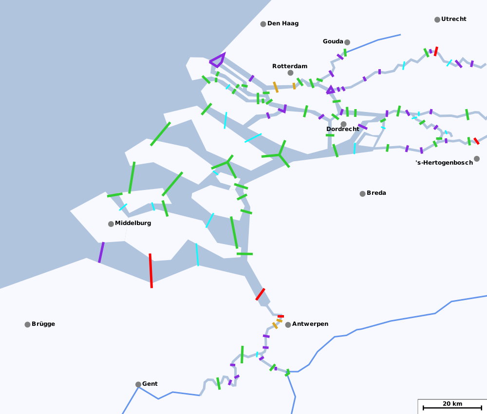
Die untenstehende Karte zeigt, welche Möglichkeiten es gibt, mit dem Fahrrad die verschiedenen Fluss- und Meeresarme an den Mündungen von Rhein, Maas und Schelde zu überqueren. Mehr Informationen gibt es, wenn man mit der Maus über die Karte fährt. Farben geben Auskunft darüber, um welche Art von Querung es sich handelt, siehe die Erläuterungen in der Legende.
Alle Angaben nach bestem Wissen und Gewissen, aber ohne Gewähr.
Tarife und Dienstplan von Fähren sollten zeitnah überprüft werden. Aktualisierungen, Ergänzungen und Berichtigungen werden gerne entgegengenommen.
|
|
Legende
|
|
Uneingeschränkt befahrbar: Brücken, Dämme oder Tunnels, die man ohne Einschränkungen mit dem Fahrrad benutzen kann. Wie im niederländischen Sprachraum üblich, sind die meisten dieser Einrichtungen mit einem Radweg oder dergleichen versehen.
|
|
|
Tunnels mit beschränktem Zugang: Zugang zur Tunnelröhre über Rolltreppe und/oder Aufzug, nachts in der Regel geschlossen. Die Tunnelröhren selbst dürfen mit dem Fahrrad befahren werden.
|
|
|
Fährverbindungen: Personen- oder Autofähren, die das ganze Jahr hindurch verkehren. Links zu weiterführenden Informationen (Tarif/Dienstplan) sind angegeben, soweit bekannt. Es sind hier nur Fähren aufgeführt, die direkt über einen Fluss- oder Meeresarm setzen! Es gibt diverse zusätzliche Fähren, die längere Strecken fahren, z.B. den Waterbus auf dem Fluss zwischen Dordrecht und Rotterdam.
|
|
|
Sommerfähren: Die hellblau eingezeichneten Verbindungen sind Personenfähren, die Fußgänger und Radfahrer befördern, aber nur im Sommerhalbjahr verkehren.
|
|
|
Verbotene Querungen: Auf den rot gekennzeichneten Wegen herrscht Radfahrverbot. Es handelt sich in der Regel um Tunnels oder Autobahnbrücken ohne Radwege. Einige solche Tunnels sind nicht angegeben, wenn sich direkt daneben eine für Radfahrer zugängliche Brücke befindet.
|
Anmerkung zu Flussquerungen: Im Bereich der hellgrau eingezeichneten Unterläufe von Rhein, Maas, Schelde und ihren Nebenläufen sind sämtliche Querungsmöglichkeiten angegeben, soweit bekannt. Die hellblau gezeichneten Abschnitte weiter flussaufwärts haben zahlreiche Brücken und stellen kein nennenswertes Verkehrshindernis mehr dar; sie sind nur informationshalber eingezeichnet.
Siehe auch: HTML-Version dieses Verzeichniss an anderer Stelle.
|
Informationen zu den Querungen
Uneingeschränkt befahrbar
*
Rupelbrug/Boulevardbrug: Brückenpaar auf Höhe von Boom über die Rupel und den Seekanal Brüssel-Schelde: – Rupelbrug: Klappbrücke mit Hochbordradweg auf beiden Seiten. – Boulevardbrug: Klappbrücke über den Seekanal mit einseitigem Radweg. –
Achtung: Die Rupelbrug war 2018 wegen Sanierungsarbeiten gesperrt. Seit April 2019 ist sie Zeitungsberichten zufolge wieder für den Verkehr geöffnet. – Auf Karte zeigen:
Rupelbrug -
Boulevardbrug*
Harmsenbrug: Schnellstraßenbrücke mit Klappsegment vom Brielse Maasdijk zum Europoort. Radweg für beide Fahrtrichtungen auf der Ostseite. –
Auf Karte zeigen*
Brielsebrug: Brücke einer Schnellstraße von der Insel Voorne-Putten auf den Brielse Maasdijk. Radwege auf beiden Seiten der Brücke. –
Auf Karte zeigen*
Botlekbrug: 2015 neu gebaute Hubbrücke für Kfz, Eisenbahn und Fahrräder innerhalb des Hafengebiets von Rotterdam. Parallel dazu besteht ein Tunnel für den Kraftverkehr. –
Auf Karte zeigen*
Hartelbrug: Brücke von Spijkenisse zum Rotterdammer Hafen mit Klappsegement. Der Radverkehr wird über eine kleine Brücke parallel zur Straßenbrücke geführt. – Achtung, die Brücke geht über die vom Brielse Maasdijk gebildete Landzunge hinweg, aber man gelangt nicht darauf. Die nächste Möglichkeit dazu ist an der Voornse Sluis. –
Auf Karte zeigen*
Gouderaksebrug: Brücken über Hollandse IJssel und Gouwekanaal bei Goud, jeweils mit Radweg. –
Auf Karte zeigen*
Brielse Maasdam: Der Brielse Maasdam führt von Oostvoorne auf eine Landzunge zwischen dem Brielse Meer und dem Hartelkanaal. Radwege direkt am Brielse Meer sowie entlang der N218. –
Auf Karte zeigen*
Suurhoffbrug: Brücke mit Klappsegment, die den Europoort mit der Landzunge des Brielse Maasdijk verbindet; separater Radweg. –
Auf Karte zeigen*
Brielse Gatdam: Künstlicher Damm, der den alten Maasarm zwischen Voorne und Maasvlakte absperrt. Der Damm ist ein Naherholungsgebiet, über den nur ein Radweg führt. – Teil der LF1 (
Noordzeeroute). –
Auf Karte zeigen*
Stadsbrug Zwijndrecht: Brücke über die Oude Maas zwischen Dordrecht und Zwijndrecht mit Radweg auf beiden Seiten. Parallel dazu verlaufen eine Eisenbahnbrücke und ein Autobahntunnel. –
Auf Karte zeigen*
Brug over de Noord: Straßenbrücke mit Klappsegment und richtungsgebundenen Radwegen auf beiden Seiten. Direkt nebenan verläuft die Autobahn durch einen Tunnel. – Von Alblasserdam kommend ist man schneller über die Treppe an der Unterführung Ruigenhill, sonst 1 km Umweg. –
Auf Karte zeigen*
Merwedebrug: Autobahnbrücke mit Klappsegment über die Beneden-Merwede bei Dordrecht. Radweg für beide Richtungen an der Ostseite. –
Auf Karte zeigen*
Martinus Nijhoffbrug: Autobahnbrücke über die Waal bei Zaltbommel. Abgetrennter Radweg für beide Fahrtrichtungen auf der Westseite. –
Auf Karte zeigen*
Wilhelminasluis: Übergang der Afgedamde Maas bei Giessen. Die N322 ist dem Kraftverkehr vorbehalten, Radfahrer auf Parallelstraße mit Treckern und Bromfietsen. –
Auf Karte zeigen*
Hedelse Brug: Brücke über die Maas zwischen 's-Hertogenbosch und Hedel. Abgetrennte Radwege auf beiden Seiten. – Nächste Brücke an der Maas 40 km flussaufwärts bei Ravenstein. –
Auf Karte zeigen*
Kromme Nol: Straßenquerung über den Heudensch Kanaal mit Radfahrstreifen. –
Auf Karte zeigen*
Van Brienenoordbrug: Autobahnbrücke über die Nieuwe Maas in Rotterdam mit Klappbrückensegment, abgetrennter Radweg an der Ostseite. – Teil der
Landelijke Fietsroute LF2 (Stedenroute / westliche Variante). –
Auf Karte zeigen*
Erasmusbrug/Willemsbrug: Brücken über die Nieuwe Maas auf Höhe der Rotterdammer Innenstadt, jeweils abgetrennte richtungsgebundene Radwege auf beiden Seiten. Letzte Brücke über Rhein/Maas vor dem Meer. – Die Erasmusbrug ist Teil der
Landelijke Fietsroute LF11 (Prinsenroute). – Auf Karte zeigen:
Erasmusbrug -
Willemsbrug*
Merwedebrug: Autobahnbrücke über die Boven-Merwede bei Gorinchem. Radwege für beide Richtungen zu beiden Seiten der Brücke. –
Auf Karte zeigen*
Keizerveersbrug: Autobahnbrücke über die Bergsche Maas. Richtungsgebundener Radwege an den Außenseiten. –
Auf Karte zeigen*
Heusdensebrug: Brücke über die Bergsche Maas bei Heusden. Abgetrennte Radwege auf beiden Seiten. –
Auf Karte zeigen*
Algerabrug: Sperrwerk über die Mündung der Hollandse IJssel. Abgetrennter Radweg an der Südseite. Ein Abschnitt ist als Klappbrücke ausgeführt. –
Auf Karte zeigen*
Moerdijkbrug: Autobahnbrücke über das Hollands Diep. Abgetrennte Radwege zu beiden Seiten der Brücke. – Teil der
Landelijke Fietsroutes LF2 (Stedenroute) und LF11 (Prinsenroute). –
Auf Karte zeigen*
Grevelingendam/Philipsdam: Dreiecksverbindung zwischen den Inseln Schouwen-Duiveland, Goeree-Overflakkee und Tholen/Sint-Philipsland. – Radverkehr auf bzw. entlang ruhiger Straßen parallel zu den Nationalstraßen. – Richtung Schouwen-Duiveland: straßenbegleitender Radweg – Richtung Goeree-Overflakkee: Straße mit Radfahrstreifen – Richtung Sint-Philipsland: gemischter Verkehr –
Auf Karte zeigen*
Hellegatsplein: Künstliche Insel, die über Dämme das Festland mit den Inseln Goeree-Overflakkee und Hoeksche Waard verbindet. Radtaugliche Verbindungen auf kleineren Straßen, die parallel zu Autobahn bzw. Schnellstraße verlaufen; teils mit Radfahrstreifen versehen. –
Auf Karte zeigen*
Festland - Zuid-Beveland: Folgende Verbindungen vom Festland nach Zuid-Beveland stehen dem Radverkehr zur Verfügung: – 1. die N289 an der Kreekraksluizen (beidseitiger Radweg) – 2. Nebenstraße über den Kanal auf Höhe von Bath (Bathseweg), Teil der LF13 (
Schelde-Rhein-Route). – 3. direkt vom Antwerpener Hafen am Deich entlang, Kfz-Verkehr nur für Anlieger (Grensweg) – Auf Karte zeigen:
Kreekraksluizen -
Bathseweg -
Grensweg*
Sint-Philipslandse Brug: Brücke vom Festland zur mit Tholen verbundenen Insel Sint Philipsland. Abgetrennter Radweg an der Nordseite der Brücke. –
Auf Karte zeigen*
Vossemerse Brug: Kurze Brücke vom Festland zur Insel Tholen bei Nieuw Vossemeer. Abgetrennter Radweg auf der Südseite. –
Auf Karte zeigen*
Thoolse Brug: Brücke über Eendracht, verbindet Stadt und Insel Tholen mit dem Festland. Die nördliche Hälfte der Brücke ist Kraftfahrstraße, die südliche Fahrrädern und landwirtschaftlichem Verkehr vorbehalten. Auf der Inselseite erreicht man diesen Brückenteil vom Hafen beim Stadtzentrum. –
Auf Karte zeigen*
Oesterdam: Schmaler Damm vom Ostende Zuid-Bevelands zur Insel Tholen. Separater Radweg auf der Deichkrone. –
Auf Karte zeigen*
Zandkreekdam: Verbindung zwischen Noord- und Zuid-Beveland. Abgetrennter Radweg. An der Nordseite Schleusenkammer mit beidseitigen Klappbrücken, so dass der Verkehr jederzeit fließen kann. –
Auf Karte zeigen*
Zeelandbrug: 5 km lange Brücke über die Oosterschelde zwischen Noord-Beveland und Schouwen-Duiveland. Längste Brücke der Niederlande. Ein Segment am nördlichen Ende ist als Klappbrücke ausgeführt. – Abgetrennter Radweg an der Westseite der Brücke. –
Auf Karte zeigen*
Spijkenisserbrug: Hubbrücke über die Oude Maas zwischen Spijkenisse und Hoogvliet. Nach Fahrtrichtung getrennte Fuß-/Radwege beidseits des Brückenfachwerks. –
Auf Karte zeigen*
Haringvlietdam: Verbindung der Inseln Goeree-Overflakkee und Voorne-Putten, eine Radroute wird über die Werkstraße parallel zur Schnellstraße geführt. – Teil der LF1 (
Noordzeeroute). –
Auf Karte zeigen*
Oosterscheldekering: 9 km langes Sperrwerk zwischen Noord-Beveland und Schouwen-Duiveland über die künstliche Insel Neeltje Jans. Radroute auf separater Werksstraße, parallel zur Schnellstraße. – Teil der LF1 (
Noordzeeroute). –
Auf Karte zeigen*
Veerse Gatdam: Damm zwischen Walcheren und Noord-Beveland. Radweg auf Deichkrone oder neben der Schnellstraße. – Teil der LF1 (
Noordzeeroute). –
Auf Karte zeigen*
Temsebrug: Letzte Brücke über die Schelde (und die längste Belgiens). Ein Segment ist als Klappbrücke ausgeführt. Radweg seitlich des westlichen Brückenteils. – Teil der
Landelijke Fietsroute LF38 (Dender-Waaslandroute). –
Auf Karte zeigen*
Brouwersdam: Damm zwischen Schouwen-Duiveland und Goeree-Overflakkee. Radweg seeseits des Damms. – Teil der LF1 (
Noordzeeroute). –
Auf Karte zeigen*
Jan Blankenbrug: Autobahnbrücke über den Lek südlich von Utrecht, mit abgetrennter Fahrspur für Fahrräder an der Ostseite. Die daneben stehende Oude Lekbrug ist für den Verkehr geschlossen. – Einzige radverkehrstaugliche Brücke auf 90 Flusskilometern zwischen Rhenen und Rotterdam. –
Auf Karte zeigen*
Voornse Sluis: Am Abzweig zweier Kanäle von der Oude Maas führt eine kleine Straße von Spijkenisse auf den Brielse Maasdijk, der sich auf 20 km Länge zwischen den beiden Kanälen bis zur Maasvlakte hinzieht. –
Auf Karte zeigen*
Calandbrug/Rozenburgse Sluis: Die Calandbrug ist eine Hubbrücke zwischen Europoort und Rozenburg abgetrennter Radweg auf der Südseite. Der direkt daneben befindliche Burgemeester Thomassentunnel ist dem Kraftverkehr vorbehalten. – Will man nicht nach Rozenburg, sondern weiter nach Rotterdam, ist es schneller, über den Neckarweg zur Rozenburger Schleuse zu fahren und den Calandkanaal dort zu überqueren. – Auf Karte zeigen:
Calandbrug -
Rozenburgse Sluis*
Bandijk: Verbindung zwischen Werkendam und dem Biesbosch, Straße mit Radfahrstreifen –
Auf Karte zeigen*
Heinenoordtunnel: Tunnel unter der Oude Maas zwischen IJsselmonde und Hoeksche Waard. – Gesonderte Röhren für Kraftverkehr, für landwirtschaftliche Fahrzeuge und für Fahrräder. Letztere Röhre ist wahlweise fahrenderweise über die Rampe der zweiten Röhre oder per Rolltreppe/Fahrstuhl zu erreichen. –
Video 1 (Zugang per Rolltreppe),
Video 2 (Zugang per Rampe) – Auf Karte zeigen:
Nordportal -
Südportal*
Stege über Dijle und Nete: Brücken für Radfahrer und Fußgänger über die Flüsse Dijle und Nete, die sich unmittelbar flussabwärts zur Rupel vereinigen. – Auf Karte zeigen:
Dijle -
NeteTunnels mit beschränktem Zugang
*
Beneluxtunnel: Tunnel unter der Nieuwe Maas zwischen Pernis und Vlaardingen. Mehrere Tunnelröhren, davon eine für Fußgänger und Radfahrer. Diese ist nur über Rolltreppen oder Fahrstühle zugänglich. Bei Bauarbeiten werden Radfahrer durch die Röhre für Dienstfahrzeuge geleitet. – Teil der
Landelijke Fietsroute LF12 (Maas- en Vestingroute). –
Video von der Durchfahrt – Auf Karte zeigen:
Nordportal -
Südportal*
Maastunnel: Tunnel mit spezieller Röhre für Radfahrer, erreichbar über Rolltreppen. –
Youtube-Video von der Durchfahrt – Auf Karte zeigen:
Nordportal -
Südportal*
Sint-Annatunnel: Tunnel für Fußgänger und Radfahrer auf Höhe des Stadtzentrums von Antwerpen. – Schrittempo, auf beiden Seiten Zugang über Aufzug oder Rolltreppen. –
Aktuelle Zustandsanzeige –
Youtube-Video – Achtung: von 2017 bis 2019 ist im Tunnel mit Bauarbeiten zu rechnen, es besteht während dieser Zeit ein kostenloser Fährdienst ca 200 m flussabwärts:
Info – Auf Karte zeigen:
Westportal -
Ostportal*
Kennedytunnel: Autobahntunnel im Süden von Antwerpen mit gesonderter Röhre für Fuß- und Radverkehr, Zugang über Aufzug oder Treppen auf beiden Seiten –
Aktuelle Zustandsanzeige –
Youtube-Video – Achtung: von 2017 bis 2019 ist im Tunnel mit Bauarbeiten zu rechnen. – Auf Karte zeigen:
Westportal -
OstportalFähren
*
Waterbus 22: Verbindung von Dordrecht-Merwekade nach Papendrecht-Veerdam, Preis 1,20 Euro (2017), Fahrrad gratis. – Teil der
Landelijke Fietsroutes LF2 (Stedenroute) und LF11 (Prinsenroute). – Fahrplan und Tarife auf der
Webseite vom Waterbus, siehe dort für weitere Verbindungen zwischen Rotterdam, Dordrecht und Sliedrecht. –
Auf Karte zeigen*
Driehoeksveer: Personenfähre am Zusammenfluss von Lek und Noord, die Ridderkerk, Kinderdijk und Krimpen verbindet. Verkehrt täglich Mai bis September, sonst Mo-Fr. Tarif 1,70 pro Person, Fahrrad gratis. – Teil der
Landelijke Fietsroutes LF2 (Stedenroute / westliche Variante) und LF11 (Prinsenroute). –
Webseite – Auf Karte zeigen:
Ridderkerk -
Kinderdijk -
Krimpen*
Moordrecht-Gouderak: Kleine Autofähre über die Hollandse IJssel. – Verkehr von April bis Oktober täglich, sonst Mo-Sa. Preis für Radfahrer 1,25 Euro (2017). –
Webseite – Der weitere Betrieb der Fähre ist mit Eröffnung der Gouderakse Brug fraglich geworden, bei Bedarf aktuelle Informationen einholen! –
Auf Karte zeigen*
De Zeemeeuw: Personenfähre über die Hollandse IJssel bei Oudekerk. – Vekehr von April bis September täglich, sonst Mo-Sa, Preis für Radfahrer 1,05 Euro (2017). –
Webseite –
Auf Karte zeigen*
Maasluis-Rozenburg: Autofähre über die Scheur, Preis für Person mit Fahrrad 1,30 Euro (2017). –
Webseite –
Auf Karte zeigen*
Gorinchem-Woudrichem: Personenfähre über die Boven-Merwede, verkehrt von Gorinchem nach Woudrichem und Sleeuwijk.Preis mit Fahrrad (2017) Euro nach Woudrichem und 1,50 Euro nach Sleeuwijk. – Teil der
Landelijke Fietsroute LF9 (NAP-route). –
Webseite -
Fährzeiten –
Auf Karte zeigen*
Werkendam-Hardinxveld: Personenfähre über die Boven-Merwede,Preis für Radfahrer 1,50 Euro (2017). Die Fähre verkehrt auch nach Gorinchem. –
Webseite -
Fährzeiten –
Auf Karte zeigen*
Puttershoek: Personenfähre über die Oude Maas, fährt ganzjährig wochentags und im Sommer auch am Wochenende.Preis 1,50 p.P. inklusive Fahrrad (2017). – Teil der
Landelijke Fietsroute LF12 (Maas- en Vestingroute). –
Webseite –
Auf Karte zeigen*
Nieuw Beijerland-Hekelingen: Autofähre über die Spui. – Tarif für eine Person mit Fahrrad 0,85 Euro (2017). –
Webseite –
Auf Karte zeigen*
Breskens-Vlissingen: Fähre über die Westerschelde, teils lange Wartezeiten, insgesamt eine Stunde einplanen für Wartezeit+Überfahrt – Tarif 4,25 Euro pro Person mit Fahrrad (2018) – Teil der LF1 (
Noordzeeroute) –
Webseite –
Auf Karte zeigen*
Fähre bei Moerzeke: Personenfähre zwischen Moerzeke einerseits und Mariekerke sowie Sint-Amands andererseits. Verstärkter Takt in den Sommermonaten. – Teil der
Landelijke Fietsroutes LF5 / Vlaanderen Fietsroute und LF38 (Dender-Waaslandroute). –
Fährplan –
Auf Karte zeigenSommerfähren
*
Ameide-Lopik: Personenfähre über den Lek, verkehr April bis Oktober. Preis 1,10 Euro für Radfahrer. –
Webseite –
Auf Karte zeigen*
Voet-Fietsveer Woudrichem: Kleine Personenfähre über die Afgedamde Maas. Verkehrt an Wochenenden, im Sommer auch unter der Woche. Preis für Radfahrer 50 Cent (2017). – Teil der
Landelijke Fietsroute LF12 (Maas- en Vestingroute). –
Webseite –
Auf Karte zeigen*
Loevestein-Vuren: Personenfähre über die Waal, fährt auch nach Woudrichem. – Fährzeit Juli-August, von Mai bis September an Wochenenden. – Tageskarte 3 Euro inkl. Fahrrad –
Webseite -
Fährzeiten –
Auf Karte zeigen*
Liniepont: Personenfähre über den Lek, verkehrt April bis September – Preis 1,50 Euro pro Person mit Fahrrad (2017) –
Webseite –
Auf Karte zeigen*
Yerseke-Gorishoek: Personenfähre von Zuid-Beveland nach Tholen – fährt nur im Hochsommer (Juli/August) – Tarif 3,50 p.P. (2017) –
Webseite –
Auf Karte zeigen*
Leeuweveerke: Personenfähre über die Amer zum Nationalpark Biesbosch. – Verkehrt von Mai bis Oktober, Preis 4 Euro p.P. (2017), Bezahlung anscheinend nur auf elektronischem Wege. –
Webseite –
Auf Karte zeigen*
Anna Jacobapolder-Bruinisse: Personenfähre von Sint-Philipsland nach Schouwen-Duiveland – fährt nur im Juli/August, Tarif 2,25 pro Person (2017) –
Webseite –
Auf Karte zeigen*
Veere-Kamperland: Personenfähre von Walcheren nach Noord-Beveland – Saison April bis September – Preis 3,70 Euro p.P. (2017) –
Webseite –
Auf Karte zeigen*
Kortgene-Wolphartsdijk: Personenfähre von Zuid-Beveland nach Noord-Beveland – Saison April bis September – Tarif 2,80 Euro p.P. (2017) –
Webseite –
Auf Karte zeigen*
Fähre Hellevoetsluis-Middelharnis: Personenfähre von Goeree-Overflakkee nach Voorne-Putten. – Verkehrt Juli/August, Tarif 7,50 Euro p.P. (2017). –
Webseite –
Auf Karte zeigen*
Fähre Stad-Nieuwendijk: Personenfähre von Goeree-Overflakkee nach Hoeksche Waard – Fährt nur im Juli/August, Tarif 5+3 Euro für eine Person plus Fahrrad –
Webseite –
Auf Karte zeigen*
Nederhemert: Autofähre über die Afgedamde Maas, verkehrt März bis Oktober, außer sonntags. Preis für Radfahrer 1 Euro (2017). – Teil der
Landelijke Fietsroutes LF7 (Oeverlandroute) und LF12 (Maas- en Vestingroute). –
Webseite –
Auf Karte zeigenVerbotene Querungen