Gerlospass: Unterschied zwischen den Versionen
Aus Radreise-Wiki
Jmages (Diskussion | Beiträge) |
Jmages (Diskussion | Beiträge) k (→Roadbook) |
||
| Zeile 6: | Zeile 6: | ||
== Roadbook == | == Roadbook == | ||
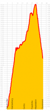
[[Bild:Gerlospass.png|thumb|right| | [[Bild:Gerlospass.png|thumb|right|100px|Höhenprofil]] | ||
=== Zell am Ziller === | === Zell am Ziller === | ||
Version vom 7. Dezember 2009, 14:41 Uhr
<googlemap lat="47.225130" lon="12.025767" zoom="11" width="800" height="400" type="map" controls="small" scale="yes" overview="no" zoomstyle="smooth"> </googlemap>
Roadbook
Zell am Ziller
- Anschluss an den Gerlospass zur Salzach (Tauern-Radweg)
5,3 km / 5 km
Hainzenberg
9 km / 14 km
Gmünd
3,2 km / 18 km
Gerlos
19,1 km / 37 km
Oberkrimml
- Anschluss an den Salzach-Radweg
